 BharatNotes
Introduction
Plate tectonics explains how the Earth's rigid outer shell, broken into plates that move, makes ocean floor, raises mountains and decides where earthquakes and volcanoes occur. These notes build the idea in the order it arrived: what seismic waves reveal about the inside of the Earth, continental drift, the mapping of the ocean floor and sea-floor spreading, the plates and their boundaries, and the Indian plate and the Himalaya; then volcanoes, eruptions, the landforms they leave and geothermal energy.
How to use this page
Boxes pick out the key ideas, the facts to remember, exam tips, pairs not to confuse, the reasons behind a pattern, worked numbers and recent news. A box whose heading calls an idea a hypothesis holds ideas scientists still debate. Every table and figure that carries data names its source beneath it, and time-sensitive figures carry their as-of date. World maps use the Equal Earth projection, which keeps areas true, and plate boundaries are drawn from the PB2002 digital model; diagrams of the interior are not to scale unless the caption says so.
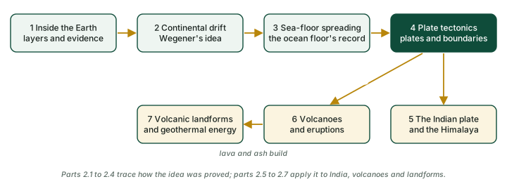
The diagram below shows how the parts connect.
Cross-paper relevance
- GS1 (Geography, primary): the interior of the Earth and seismic waves, continental drift, sea-floor spreading, plate tectonics and plate boundaries, the Indian plate and the Himalaya, volcanoes and volcanic landforms
- GS3 (Disaster management): earthquakes and seismic zoning (IS 1893), tsunamis, volcanic hazards and alert levels
- GS3 (Energy): geothermal energy, India's hot springs and the wells at Puga Valley, Ladakh
The Seven Parts
The notes are in seven parts, in reading order. Each part has its own diagrams and sources.
- Inside the Earth: direct and indirect sources of information, what an earthquake is (fault, focus and epicentre), P, S and surface waves, the shadow zones and what they prove about the core, crust, mantle and core, lithosphere and asthenosphere, the types of earthquakes NCERT lists, and magnitude versus intensity.
- Continental Drift: the ideas before Wegener, Wegener's hypothesis and Pangaea, the evidence for drift, the forces Wegener proposed, and why the theory was rejected.
- Mapping the Ocean Floor and Sea-Floor Spreading: mapping the ocean floor and its relief, where earthquakes and volcanoes occur, convection currents, Hess and sea-floor spreading, palaeomagnetism and the magnetic stripes, the age of the ocean floor and deep-sea drilling, pillow lava and hydrothermal vents.
- Plate Tectonics and Plate Boundaries: the theory of plate tectonics, the plates of the world, divergent, convergent and transform boundaries, how fast plates move, what drives them, where earthquakes happen, and lessons from the earthquakes of 2023 to 2025.
- The Indian Plate and the Himalaya: the Indian plate and its boundaries, the journey from Gondwana and how fast India travelled, the collision and the rise of the Himalaya, present convergence, the Andaman-Sunda subduction zone, and earthquake zoning and recent events in India.
- Volcanoes and Eruptions: magma and lava, why some volcanoes explode, volcanoes by activity, eruption style and form, the VEI, where volcanoes occur, great eruptions and climate, Barren Island and Narcondam, monitoring and alert levels, and the eruptions of 2024-2026.
- Volcanic Landforms and Geothermal Energy: volcanic and plutonic rocks, intrusive and extrusive landforms, aa, pahoehoe and pillow lava, the Deccan Traps, hotspot chains, Yellowstone, hot springs and geysers, and geothermal energy.
Quick Revision
The whole topic at a glance
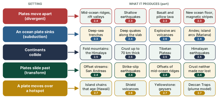
Almost everything in these notes follows from one fact: the rigid outer shell of the Earth is broken into plates that move. Where they move apart, ocean floor is made; where an ocean plate sinks, trenches, deep earthquakes and explosive volcanoes follow; where continents collide, mountains rise; where plates slide past, the crust is neither made nor lost; and a hotspot under a moving plate leaves a chain of volcanoes. The diagram below maps each setting to what it produces. When a question looks unfamiliar, find its setting on this chart first.
How the ideas arrived
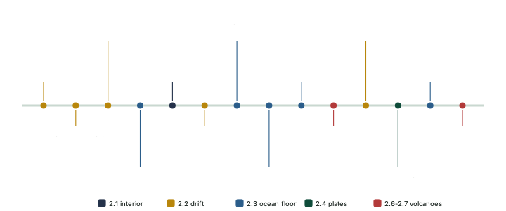
The theory was built over four centuries, and examiners like to pair names with ideas. The diagram below sets the ideas in order. Note the two years for Hess: NCERT gives 1961, and his paper appeared in 1962.
Numbers to remember
| Number | What it is |
|---|---|
| 2,900 km | depth of the core-mantle boundary |
| 105° / 145° | limits of the shadow zone, measured from the epicentre |
| 5 / 30 / 70 km | crust under oceans / continents / the Himalaya (NCERT) |
| 10-200 km | thickness of the lithosphere (NCERT) |
| ~200 Ma | Pangaea began to break up; no ocean floor is older (NCERT) |
| 7 / 52 | major plates (NCERT) / plates in the PB2002 model |
| <2.5 to >15 cm a year | spreading rates: Arctic Ridge (slowest) to East Pacific Rise (fastest) (NCERT) |
| 37-44 mm/yr | India-Asia convergence by GPS along the Himalaya |
| 0 to 8 | the VEI; above VEI 2, each step about ten times more tephra |
| 1787 | first recorded eruption of Barren Island |
| 75% / 90% | of active volcanoes / earthquakes on the Ring of Fire |
| 381 / ~10.6 GW | hot springs / geothermal potential of India |
Sources: NCERT Class XI, Fundamentals of Physical Geography, ch. 3 and ch. 4; Bird (2003), PB2002; Banerjee and Bürgmann (2002); USGS YVO, the VEI; Smithsonian GVP, Barren Island; National Geographic, Ring of Fire; PIB, 4 Sep 2026 (GSI figures).
Where NCERT and research differ
| Topic | NCERT | Research or other source |
|---|---|---|
| Fit of the continents | At the 1,000-fathom line | Bullard and others (1965): best fit at the 500-fathom contour |
| Who drew the 1858 maps | "Antonio Pellegrini" | Antonio Snider-Pellegrini |
| S-wave shadow zone | "A little over 40 per cent of the earth surface" | About 37% by geometry from the 105° limit (computed) |
| Hess and sea-floor spreading | Hess (1961) | Paper published in 1962; Dietz named the idea in 1961 |
| India leaves Gondwana | Journey began about 200 Ma | The plate separated around 130-120 Ma |
| India meets Asia | About 40-50 Ma | Most authors: about 55-50 Ma |
| Deccan Traps | Around 60 Ma | Main eruptions about 66-65 Ma, around the K-Pg boundary |
| Number of plates | Seven major plates and several minor ones | PB2002 model: 52 plates |
| The Indian plate | One plate with Australia | PB2002: separate India and Australia plates |
| What drives the plates | Mantle convection | Debated: ridge push, slab pull and mantle drag |
| Kinds of volcano | Five: shield, composite, caldera, flood basalt, mid-ocean ridge | USGS also lists cinder cones and lava domes |
As set out, with sources, in the seven parts. In an NCERT-based answer write the NCERT figure; know the other, and name its basis if you use it.
Pairs that are easily confused
| Pair | The difference |
|---|---|
| Focus / epicentre | Where the rock breaks, underground / the point on the surface directly above it. |
| Magnitude / intensity | One number for the energy of the earthquake / the shaking at a place, in Roman numerals I to XII. |
| Crust / lithosphere | Ends at the Moho / the crust plus the rigid uppermost mantle. |
| Lithosphere / asthenosphere | Rigid outer shell / the weak, semi-solid layer below; not molten. |
| Continental drift / plate tectonics | Continents move, Wegener 1912 / plates of lithosphere move, 1967 (NCERT). |
| Hess / Dietz | Put forward sea-floor spreading / named it. |
| Vine and Matthews / Glomar Challenger | First test from the stripes, 1963 / drill cores that clinched it, 1968. |
| Divergent / convergent / transform | Crust made / crust destroyed or thickened / neither. |
| Magma / lava | Molten rock below the surface / the same rock once erupted. |
| Effusive / explosive | Runny, low-silica basalt that lets gas escape / sticky, high-silica dacite and rhyolite that traps it. |
| Phreatic / Plinian | A steam blast with no new magma / the most powerful style, with enormous columns of tephra (St Helens 1980, Pinatubo 1991). |
| Crater / caldera | Small summit vent made by explosions / a basin 2-50 km across made by collapse. |
| Sill / dyke | A horizontal sheet of intruded rock / a vertical wall. |
| Laccolith / lapolith | A dome with a level base / a saucer, concave to the sky. |
| Volcanic / plutonic rock | Cooled at the surface / cooled within the crust. |
| Aa / pahoehoe | Rubbly, clinkery lava / smooth, ropy lava. |
| Hot spring / geyser | Open plumbing / constrictions that trap superheated water. |
| Makran / Makrana | The coast on the western boundary of the Indian plate, beside the Kirthar range (NCERT writes "Makrana coast") / the marble town of Rajasthan. |
Definitions as explained in the seven parts, with their sources there.
Exam Strategy
For Prelims: Focus on the numbers: the core-mantle boundary (2,900 km), the shadow-zone limits (105° and 145°), the crust under oceans, continents and the Himalaya (5 / 30 / 70 km), the seven major plates, the VEI (0 to 8) and Barren Island's first recorded eruption (1787). Learn the pairs examiners set against each other, such as focus and epicentre, magnitude and intensity, crust and lithosphere, and Hess and Dietz. Where NCERT and research differ, know both figures.
For Mains GS-I: Draw diagrams wherever the question allows: a ridge with symmetrical magnetic stripes and a trench, the three plate boundaries as block diagrams with arrows, India's path north and a cross-section of the collision, and a silica scale from basalt to rhyolite. In an NCERT-based answer write the NCERT figure, and name the basis of any research figure you add.
Framing long answers
These practice questions were written for these notes. Each outline shows a structure, the facts worth quoting and the diagram worth drawing; write the answer in your own words within the word limit.
How did the study of the ocean floor supply the mechanism that continental drift lacked? (250 words)
- Open: Wegener (1912) had strong evidence (fit, rocks, tillite, placers, fossils) but no adequate force; his pole-fleeing and tidal forces were "totally inadequate" (NCERT).
- Mapping: echo sounding (after the First World War) and later surveys revealed a global mid-ocean ridge and deep trenches.
- Hess: new crust forms at the ridges and sinks at the trenches (NCERT 1961; paper 1962); Dietz named it sea-floor spreading (1961). Holmes had proposed mantle convection in the 1930s.
- Proof: mirror-image magnetic stripes (Vine and Matthews, 1963); drill cores of 1968 showed the floor grows older away from the ridge; nowhere is it older than about 200 million years (NCERT).
- Draw: a ridge with symmetrical stripes and a trench (see Mapping the Ocean Floor and Sea-Floor Spreading).
- Close: continents ride on moving plates rather than ploughing through the ocean floor: plate tectonics (NCERT dates it 1967).
Distinguish between divergent, convergent and transform plate boundaries, with one landform and one example of each. (150 words)
- Divergent: plates move apart and crust is made; mid-ocean ridges and continental rifts (East African Rift); shallow earthquakes, basalt eruptions.
- Convergent: crust is destroyed or thickened; ocean-continent (Andes), ocean-ocean (Mariana arc), continent-continent (Himalaya); trenches, deep earthquakes along the sinking slab, explosive volcanoes.
- Transform: plates slide past and crust is neither made nor destroyed; the San Andreas Fault, with offset streams such as Wallace Creek; strike-slip earthquakes.
- Draw: the three boundaries in block diagrams with arrows (see Plate Tectonics and Plate Boundaries).
How did the collision of the Indian and Eurasian plates raise the Himalaya? Discuss what it means for earthquakes in India. (250 words)
- Journey: India left Gondwana (NCERT: from about 200 Ma; research: separation around 130-120 Ma) and moved north; convergence with Asia was about 8 cm a year before 66 Ma, about 16 cm a year at its peak, and about 5 cm a year by 35 Ma (van Hinsbergen and others, 2011).
- Collision: NCERT dates it about 40-50 Ma; most research about 55-50 Ma. Continental crust is too light to sink, so it thickens (up to 70 km under the Himalaya, NCERT); most of the height of the Himalaya and Tibet was gained in the last 10 million years (USGS).
- Today: GPS gives 37-44 mm a year of convergence along the Himalaya (Banerjee and Bürgmann).
- Earthquakes: the strain is released in Himalayan earthquakes; the eastern edge is the Andaman-Sunda subduction zone (2004, M9.1, thrusting); India’s seismic zones run from II to V under IS 1893 (Part 1):2016.
- Draw: India’s path north and a cross-section of the collision (see The Indian Plate and the Himalaya).
- Close: preparedness: building codes and zoning matter because convergence continues.
Why are some volcanic eruptions explosive and others effusive? Illustrate with examples. (150 words)
- Key idea: silica controls viscosity, and viscosity controls how easily gas escapes.
- Effusive: low-silica basalt is runny; gas bubbles escape quietly, giving lava fountains and flows (Hawaiian shield volcanoes such as Kilauea).
- Explosive: high-silica dacite and rhyolite are sticky; gas is trapped until the magma shatters into ash and pumice (Mount St Helens 1980, Pinatubo 1991).
- Water: water meeting magma can make an eruption violent; phreatic eruptions are steam blasts with no new magma.
- Setting: explosive arc volcanoes sit above subduction zones (Ring of Fire); effusive basalt erupts at ridges and hotspots.
- Draw: a silica scale from basalt to rhyolite with eruption styles (see Volcanoes and Eruptions).
Discuss the potential of geothermal energy in India and the obstacles to its use. (150 words)
- Source: heat from the Earth’s interior, much of it from the decay of uranium, thorium and potassium; wells bring hot water and steam to the surface, and the fluid can be reinjected (PIB).
- Potential: 381 hot springs in 10 geothermal provinces, about 10.6 GW (Geological Survey of India, as reported by PIB, 4 Sep 2026).
- Recent: two 1,000 m wells at Puga Valley, Ladakh (July 2026), which the government describes as India’s first geothermal wells; they are meant to pave the way for a 1 MW demonstration plant (PIB).
- Obstacles: commercial-scale generation is not yet established; the government’s priorities include reusing abandoned oil and gas wells and drilling expertise.
- World: about 15.67 GW installed by the end of 2025, about two-thirds of it in five countries (PIB).
- Close: besides electricity, PIB lists direct uses such as district heating, agriculture, aquaculture, and space heating and cooling.
Vocabulary
Pangaea
- Pronunciation: /pænˈdʒiːə/
- Definition: The single supercontinent comprising all of Earth's major landmasses, which began to split around 200 million years ago (NCERT; USGS puts the start of the break-up at about 225-200 million years ago), first into two large masses, Laurasia (northern) and Gondwanaland (southern).
- Root: Greek pan (πᾶν) = all; gaia (γαῖα) = earth, land
- Origin: From Greek pan (πᾶν, "all") + gaia (γαῖα, "earth, land"); the name of the hypothetical unified landmass from which, in Wegener's hypothesis, the present continents drifted apart.
- Part of Speech: noun (proper noun)
- Word Family: Pangaean (adj); No standard derived forms; related: Gondwana (n), Laurasia (n)
- Usage: Just as the geological breakup of Pangaea reshaped the planet's surface over aeons, the unravelling of a once-monolithic global order into competing blocs compels India to recalibrate its foreign policy for a more fragmented, multipolar world.
- Synonyms: supercontinent, Pangea, primordial landmass, Urkontinent, all-earth landmass
- Antonyms: Laurasia, Gondwana, Panthalassa (the surrounding ocean)
- Mnemonic: PAN + GAEA = "all" + "earth" (Gaia, the Greek earth-goddess): Pangaea is the "all-earth" supercontinent where every landmass was once joined as one.
- UPSC: The supercontinent from which today's landmasses separated. Alfred Wegener presented the idea publicly on 6 January 1912, and the shift he made is the examinable one: Wegener argued that the parts of Pangaea had moved apart laterally over geological time. Continental drift lacked a mechanism, and plate tectonics later supplied it, which is why the two should be presented as successive rather than as the same theory.
- Nuance: Pangaea is the single supercontinent. Laurasia and Gondwana are the northern and southern masses into which it split. Panthalassa is the surrounding ocean, and Tethys the sea between Laurasia and Gondwana. Continental drift is Wegener's hypothesis; plate tectonics is the later theory that supplied the mechanism.
- Hindi: पैंजिया (painjiyā), महाद्वीपीय विस्थापन being continental drift.
- FAQ: What was Pangaea? || The single supercontinent from which the present continents separated, proposed by Alfred Wegener, who presented the idea publicly in January 1912.
- FAQ: How is continental drift different from plate tectonics? || Continental drift described the movement but could not explain what drove it. Plate tectonics later supplied the mechanism through seafloor spreading and plate motion.
Subduction
- Pronunciation: /səbˈdʌkʃən/
- Definition: The geological process in which one tectonic plate slides beneath another at a convergent plate boundary, descending into the mantle where it is recycled, creating deep ocean trenches, volcanic arcs, and some of the world's most powerful earthquakes.
- Root: Latin sub- = under + ducere = to lead, draw; subductio = a drawing under
- Origin: From Latin sub ("under") + ducere ("to lead, to draw"); literally "to draw under"; in plate tectonics the term describes the fate of oceanic lithosphere at destructive plate margins.
- Part of Speech: noun
- Word Family: subduct (v), subducted (adj), subducting (v pres.p), subduction (n), subduction-zone (n compound)
- Usage: Just as the slow subduction of one tectonic plate beneath another stores immense strain that is eventually released as a catastrophic earthquake, the steady erosion of institutional accountability builds latent pressures within the polity that, if left unaddressed, can rupture into systemic crisis.
- Synonyms: underthrusting, submergence, descent, sinking, undersliding
- Antonyms: obduction, uplift, emergence, upthrust
- Mnemonic: SUB ("under") + DUCT ("to lead/carry", as in "aqueduct") = one plate is led UNDER another, ducking down into the mantle.
- UPSC: The process by which one lithospheric plate descends beneath another at a convergent margin. It is the single most productive concept in GS1 physical geography because so much follows from it: deep ocean trenches, volcanic arcs, the deepest earthquakes and the recycling of crust back into the mantle. The rule to state is that the denser plate subducts, which is why oceanic lithosphere descends beneath continental.
- Nuance: Subduction is one plate descending beneath another at a convergent margin. Obduction is the rarer reverse case where oceanic crust is thrust onto a continent. Seafloor spreading creates new crust at divergent margins. Collision occurs where two continental plates meet and neither subducts readily, producing mountain belts such as the Himalaya.
- Hindi: क्षेपण (kshepan) or प्रविष्ठन (pravishthan).
- FAQ: What is subduction? || The process by which one tectonic plate descends beneath another at a convergent boundary and is recycled into the mantle.
- FAQ: Which plate subducts when two plates converge? || The denser one, which is why oceanic lithosphere typically descends beneath the lighter continental lithosphere.
Asthenosphere
- Pronunciation: /æsˈθɛnəsfɪər/
- Definition: The weak, hot, semi-solid (not molten) layer of Earth's upper mantle beneath the lithosphere, considered to extend to about 400 km (NCERT); it can soften and flow over geologic time, and the rigid lithosphere is thought to "float" or move about on it (USGS).
- Root: Greek asthenes (weak, without strength) + sphaira (sphere); the name is credited to J. Barrell (1914).
- Origin: From Greek asthenes (ἀσθενής, "weak, without strength") + sphaira (σφαῖρα, "sphere"); the name, credited to J. Barrell (1914), describes the weak, deformable zone beneath the strong lithosphere.
- Part of Speech: noun
- Word Family: asthenosphere (n), asthenospheric (adj); No standard verb or further derivatives in English
- Usage: Just as the rigid lithosphere of statute can move only because it rests upon the yielding asthenosphere of administrative discretion, so a constitutional order endures not through rigidity alone but through the pliant lower stratum of conventions and institutional flexibility that absorbs the persistent stresses of a changing polity.
- Synonyms: upper mantle layer, ductile mantle zone, plastic mantle, low-velocity zone, sphere of weakness, rheosphere
- Antonyms: lithosphere, crust
- Mnemonic: A-STHENO = 'a' (without) + 'sthenos' (strength); think of the comic-book strongman who LOSES his strength: the asthenosphere is the Earth's WEAK, soft layer beneath the strong, rigid lithosphere.
- UPSC: The weak, semi-solid (not molten) layer of the upper mantle beneath the lithosphere, over which the plates move. Its mechanical behaviour is what matters: because it deforms plastically it permits both plate motion and isostatic adjustment. Note that the lithosphere-asthenosphere division is defined by mechanical strength, not by chemical composition, which is exactly the distinction that separates it from the crust-mantle boundary.
- Nuance: The asthenosphere is the weak, ductile upper mantle layer. The lithosphere is the rigid outer shell of crust plus uppermost mantle, defined mechanically. The crust is defined chemically and is separated from the mantle by the Moho. The mesosphere or lower mantle lies beneath the asthenosphere and is more rigid again.
- Hindi: दुर्बलतामंडल (durbaltāmandal); स्थलमंडल (sthalmandal) is the lithosphere.
- FAQ: What is the asthenosphere? || The weak, semi-solid (not molten) layer of the upper mantle beneath the lithosphere, over which tectonic plates move.
- FAQ: How is the lithosphere-asthenosphere boundary different from the crust-mantle boundary? || The lithosphere-asthenosphere boundary is defined by mechanical strength. The crust-mantle boundary, marked by the Moho, is defined by chemical composition.
Atoll
- Pronunciation: /ˈætɒl/
- Definition: A ring-shaped coral reef, island, or chain of islands enclosing or nearly enclosing a shallow lagoon, typically formed as a volcanic island subsides beneath the sea surface while coral growth continues upward. Charles Darwin's subsidence theory remains the foundational explanation. In 1952, hole F-1 was drilled on Elugelab Island, Enewetak Atoll, to a depth of 4,630 feet (about 1,411 m) (USGS). In the Indian Ocean, Lakshadweep (36 islands: 12 atolls, three reefs, five submerged banks and ten inhabited islands) is the standard Indian example of coral island formation.
- Root: Maldivian/Dhivehi atolu = administrative district of coral islands; no Latin root
- Origin: Borrowed into English via Portuguese atol from Maldivian Dhivehi atolu, meaning both a ring-shaped reef and a local administrative unit.
- Part of Speech: noun (countable)
- Word Family: atoll (noun), atollic (adjective, rare)
- Usage: The Lakshadweep archipelago, made up of 12 atolls, three reefs and five submerged banks, is low-lying and exposed to sea-level rise.
- Synonyms: coral ring, coral atoll, lagoonal reef, annular reef, reef island
- Antonyms: continental island, volcanic high island, barrier island, peninsula
- Mnemonic: An atoll forms a natural 'O' shape, like the letter in the middle of 'atoll', enclosing a calm lagoon. Imagine a doughnut (a-TOLL = a ring you pay toll at the gate of a lagoon).
- UPSC: A ring-shaped coral reef enclosing a lagoon. Charles Darwin's subsidence theory explains the form through a three-stage sequence: a fringing reef forms around a volcanic island, becomes a barrier reef as the island subsides while coral growth keeps pace, and is left as an atoll when the island finally disappears beneath the surface. Lakshadweep provides the Indian example.
- Nuance: An atoll is a ring reef enclosing a lagoon with no central island remaining. A fringing reef lies directly against the shore. A barrier reef is separated from the shore by a lagoon while the island is still present. A coral cay is a small sand island formed on a reef platform.
- Hindi: प्रवाल वलय (pravāl valay) or एटोल, the loanword.
- FAQ: What is an atoll? || A ring-shaped coral reef enclosing a central lagoon, with no volcanic island remaining above the surface.
- FAQ: How did Darwin explain atoll formation? || Through subsidence: a fringing reef around a volcanic island becomes a barrier reef as the island sinks and coral grows upward, and becomes an atoll once the island is fully submerged.
Barchan
- Pronunciation: /ˈbɑːkən/
- Definition: A crescent-shaped sand dune with the concave (slip) face oriented downwind and two forward-pointing horns, formed where sand supply is limited and wind direction is predominantly unidirectional. Barchans migrate downwind. In India, barchans occur in the Thar Desert of Rajasthan.
- Root: Kazakh/Turkic barkhan = a type of sand dune; borrowed into geological literature via Russian
- Origin: The term entered Western scientific literature from Russian бархан (barkhan), which is borrowed from Kazakh, a Turkic language spoken across Central Asian desert regions where these dunes are common.
- Part of Speech: noun (countable)
- Word Family: barchan (noun), barchanoid (adjective, describing transitional dune ridges)
- Usage: Migrating barchans in the Thar Desert can bury agricultural land and threaten rural settlements in western Rajasthan.
- Synonyms: crescent dune, crescentic dune, transverse dune (partial), lunate dune
- Antonyms: star dune, longitudinal dune, seif dune, parabolic dune
- Mnemonic: A barchan looks like a BAR (C-shaped bracket) when viewed from above: the two 'horns' of the crescent point downwind like arms reaching forward. 'Bar-khan' = a bar-shaped khan (ruler) charging downwind.
- UPSC: A crescent-shaped sand dune whose horns point downwind, formed where sand supply is limited and wind direction is consistent. In GS1 it belongs to arid landform questions, and the detail that distinguishes a good answer is the asymmetry: a gentle windward slope and a steep leeward slip face, with the dune migrating downwind as sand is transferred over the crest.
- Nuance: A barchan is crescent-shaped with horns pointing downwind, under a unidirectional wind. A seif or longitudinal dune is elongated parallel to the wind. A transverse dune lies at right angles to the wind where sand is abundant. A star dune forms where wind direction is variable.
- Hindi: बरखान (barkhān) or अर्धचंद्राकार बालुका स्तूप.
- FAQ: What is a barchan dune? || A crescent-shaped sand dune with its horns pointing downwind, formed where sand supply is limited and the wind blows consistently from one direction.
- FAQ: How does a barchan move? || Sand is carried up the gentle windward slope and deposited on the steep leeward slip face, causing the whole dune to migrate downwind.
Cirque
- Pronunciation: /sɜːk/
- Definition: An amphitheatre-shaped, steep-walled hollow carved into a mountainside by glacial erosion, typically at the head of a glacial valley where snow accumulates, compacts to ice, and rotational sliding abrades the bedrock basin. When the ice melts, a cirque may hold a glacial lake called a tarn. In the Himalayas, numerous cirques and tarns are found in the higher zones of Himachal Pradesh and Uttarakhand, and understanding their formation is essential for UPSC questions on glacial landforms.
- Root: French cirque = circle, amphitheatre; from Latin circus = ring, circle
- Origin: Borrowed directly from French cirque, which derives from Latin circus (ring or circular arena, as in Roman chariot tracks). The synonym corrie (Scottish Gaelic) and cwm (Welsh) reflect local terminology for the same landform.
- Part of Speech: noun (countable)
- Word Family: cirque (noun), cirque glacier (compound noun), corrie (synonym noun)
- Usage: A cirque at the head of a glaciated valley often holds a small lake, or tarn, once the ice has melted.
- Synonyms: corrie, cwm, glacial hollow, armchair valley, niche glacier hollow
- Antonyms: alluvial plain, delta, floodplain, piedmont
- Mnemonic: A cirque is shaped like a CIRCular amphitheatre carved by a glacier, the same root as 'circus ring'. Picture an ancient Roman circus carved into a mountain by ice.
- UPSC: An armchair-shaped hollow excavated at the head of a glacial valley by plucking and abrasion. It is the starting point of the classic glacial sequence in GS1: cirques enlarge and coalesce to produce arêtes between them and a horn where three or more meet. Naming that progression is worth more than describing the feature alone.
- Nuance: A cirque is the hollow at a glacier's head. A tarn is the lake that occupies it after the ice retreats. An arête is the sharp ridge between two adjacent cirques. A horn is the pyramidal peak left where several cirques cut back into the same summit.
- Hindi: हिमज गह्वर (himaj gahvar) or सर्क, the loanword.
- FAQ: What is a cirque? || An armchair-shaped hollow carved at the head of a glacial valley by the plucking and abrasion of ice.
- FAQ: What landforms develop from cirques? || As cirques enlarge they form arêtes between adjacent hollows, and where several cut back into one summit they leave a pyramidal horn.
Coriolis
- Pronunciation: /ˌkɒrɪˈəʊlɪs/
- Definition: The apparent deflection of freely moving objects (winds, ocean currents, projectiles) to the right in the Northern Hemisphere and to the left in the Southern Hemisphere, arising from Earth's rotation rather than any actual force. The Coriolis effect, named after the French engineer Gaspard-Gustave de Coriolis, is fundamental to the formation of trade winds, westerlies, jet streams, cyclonic circulation, and the geostrophic balance governing ocean gyres. In UPSC Climatology, the Coriolis effect explains the anticlockwise rotation of Northern Hemisphere cyclones (e.g., Bay of Bengal tropical cyclones) versus clockwise rotation in the Southern Hemisphere.
- Root: Proper noun: from Gaspard-Gustave de Coriolis, French mathematician and engineer
- Origin: Named after Gaspard-Gustave de Coriolis, who gave a mathematical treatment of motion in rotating reference frames. It is a fictitious (inertial) force, real only in a rotating frame of reference.
- Part of Speech: noun (used attributively); proper noun (eponym)
- Word Family: Coriolis effect (compound noun), Coriolis force (compound noun), Coriolis parameter (technical noun)
- Usage: The Coriolis effect deflects the southwest monsoon winds northeastward as they cross the equator, converting the southerly flow into the moisture-laden southwesterlies that drive India's June–September rainfall season.
- Synonyms: Coriolis force, Coriolis deflection, rotational deflection, inertial deflection
- Antonyms: pressure-gradient force (the force it balances in geostrophic wind)
- Mnemonic: Coriolis Curves: Right in the North, Left in the South. Picture a merry-go-round turning anticlockwise, as the Northern Hemisphere does when seen from above the North Pole: a ball rolled across it seems, to a rider, to curve to the right.
Denudation
- Pronunciation: /ˌdɛnjʊˈdeɪʃən/
- Definition: The collective group of processes, including weathering, mass wasting, erosion, and transport, that progressively strip and lower the land surface, ultimately reducing highlands toward base level. Denudation is distinct from erosion alone because it encompasses all agents of surface lowering: water, wind, ice, gravity, and chemical breakdown. The concept underpins Davis's Geographical Cycle of Erosion and is central to UPSC questions on landscape evolution, soil degradation, and the long-term development of peneplains and inselbergs.
- Root: Latin denudare = to lay bare; de- = away/completely + nudare = to strip (from nudus = naked)
- Origin: From Latin denudatio, the noun form of denudare (to strip bare), which entered English via Old French in the general sense of stripping or laying bare.
- Part of Speech: noun (uncountable)
- Word Family: denude (verb), denuded (adjective), denudational (adjective), denuder (noun, rare)
- Usage: Accelerated denudation of the Himalayan foothills, driven by deforestation and intense monsoon rainfall, delivers large volumes of sediment into the Ganga–Brahmaputra river system.
- Synonyms: erosion, degradation, ablation, stripping, surface lowering, wearing down
- Antonyms: aggradation, deposition, accretion, uplift, orogeny
- Mnemonic: DENUDation = making the land NUDE (bare and stripped). The Latin root nudus (naked) is right inside the word: the landscape is literally undressed by erosion over geological time.
- UPSC: The overall lowering of the land surface by the combined action of weathering, mass wasting, erosion and transport. Its value in GS1 is as the umbrella term: weathering breaks rock in place, erosion removes the debris, and denudation is the aggregate outcome. Answers that use denudation and erosion interchangeably lose the hierarchy the examiner is testing.
- Nuance: Denudation is the total wearing down of the land surface. Weathering breaks rock in situ without transport. Erosion detaches and removes material. Mass wasting is downslope movement under gravity, and all three are components of denudation.
- Hindi: अनाच्छादन (anāchchhādan).
- FAQ: What is denudation? || The overall wearing down and lowering of the land surface through weathering, mass wasting, erosion and transport combined.
- FAQ: What is the difference between weathering and erosion? || Weathering breaks rock down where it lies. Erosion detaches and carries the material away.
Drumlin
- Pronunciation: /ˈdrʌmlɪn/
- Definition: A smooth, elongated, oval hill of glacially deposited till, streamlined in the direction of ice flow with the steeper (stoss) end facing the oncoming glacier and the gentler (lee) tail pointing downflow. Drumlins typically occur in swarms called 'drumlin fields' and are diagnostic indicators of past continental glaciation.
- Root: Irish druim = ridge, back (of a hill); with diminutive suffix -lin; from Old Irish druimm
- Origin: The word entered English from Irish drumlín (diminutive of druim, ridge or back). The term reflects the Irish landscape of County Down and Galway, where drumlins create the characteristic 'basket of eggs' topography.
- Part of Speech: noun (countable)
- Word Family: drumlin (noun), drumlinoid (adjective), drumlin field (compound noun), drumlinised (adjective, rare)
- Usage: The 'basket of eggs' topography of drumlins, aligned parallel to former ice-flow directions, provides palaeo-glaciologists with reliable proxy data for reconstructing past ice-sheet flow.
- Synonyms: glacial hill, till mound, streamlined glacial ridge, ice-moulded hill
- Antonyms: kettle hole, glacial trough, cirque, outwash plain
- Mnemonic: DRUM-lin: imagine an upturned DRUM laid on its side, smooth, oval, and elongated, pointing in the direction the glacier 'drummed' its way forward. The steep end faced the ice, the tail drifted away.
- UPSC: A smooth, elongated hill of glacial till, shaped beneath moving ice and aligned with the direction of flow. Its diagnostic form is the asymmetry, a blunt steep stoss end facing the ice and a gently tapering lee end, which is why drumlin fields are read as indicators of former ice-movement direction. That interpretive use is what makes it examinable rather than merely descriptive.
- Nuance: A drumlin is a depositional hill of till streamlined beneath ice. A moraine is glacial debris deposited at the margin or base without that streamlined form. An esker is a sinuous ridge of meltwater-laid sediment. A roche moutonnée is an erosional bedrock form with the opposite asymmetry.
- Hindi: ड्रमलिन (dramlin), used as a loanword; हिमोढ़ टीला descriptively.
- FAQ: What is a drumlin? || A smooth elongated hill of glacial till moulded beneath moving ice and aligned with the direction of ice flow.
- FAQ: Why are drumlins useful to geographers? || Their asymmetric shape and alignment record the direction in which the ice was moving, so drumlin fields help reconstruct former glaciers.
Eolian
- Pronunciation: /iːˈəʊlɪən/
- Definition: Of, relating to, or produced by the action of wind; used to describe landforms, deposits, and sedimentary processes driven by wind energy. Eolian (also spelled Aeolian) processes are dominant geomorphic agents in arid and semi-arid environments, responsible for features such as sand dunes, loess deposits, ventifacts, and deflation hollows. In India, eolian processes shape the Thar Desert landscape and have deposited loess-like sediments in parts of Punjab and Rajasthan, making the term essential for UPSC physical geography.
- Root: Latin Aeolus = Greek god of winds (from Greek Aiolos); -ian = adjectival suffix
- Origin: Derived from the name of Aeolus, the keeper of the winds in Greek mythology (Aiolos in Greek), via Latin Aeolianus. The American spelling 'eolian' (dropping the initial 'A') became standard in US geological literature while 'aeolian' is preferred in British usage.
- Part of Speech: adjective; also noun (modifier)
- Word Family: aeolian/eolian (adjective), aeolianite (noun, wind-deposited limestone), aeolian harp (compound noun)
- Usage: Eolian sand transport in the Thar Desert intensifies during the pre-monsoon season (April–June), when strong westerly winds from the Sindh plains mobilise sediment and threaten to engulf agricultural land in Barmer and Jaisalmer districts.
- Synonyms: wind-driven, aeolian, wind-formed, anemogenic, wind-deposited
- Antonyms: fluvial (water-driven), glacial (ice-driven), marine (sea-driven), alluvial
- Mnemonic: Eolian = AEolus, the Greek wind god. Whenever you see Eolian, think of Aeolus opening his bag of winds in Homer's Odyssey; the wind scours, deposits, and sculpts the desert landscape.
- UPSC: Relating to wind action, from Aeolus, the Greek keeper of the winds. In GS1 it labels the whole family of arid and coastal processes and landforms produced by wind, from deflation hollows and yardangs to dunes and loess. Its usefulness is as a category marker, letting an answer group processes by agent rather than listing landforms at random.
- Nuance: Eolian processes are driven by wind. Fluvial processes are driven by running water. Glacial by ice, and marine or littoral by waves and currents. Loess is the fine wind-deposited silt that is among the most extensive eolian deposits.
- Hindi: वातज (vātaj) or पवनकृत (pavankrit), wind-formed.
- FAQ: What does eolian mean? || Relating to or produced by the action of wind, from Aeolus, the Greek god of the winds.
- FAQ: What are common eolian landforms? || Sand dunes such as barchans and seifs, deflation hollows, yardangs and extensive loess deposits.
Esker
- Pronunciation: /ˈɛskə/
- Definition: A long, winding ridge of stratified sand and gravel deposited by meltwater streams flowing within, beneath, or on top of a glacier, forming a sinuous ridge on the land surface after the ice retreats. Eskers can extend for hundreds of kilometres and often follow ancient sub-glacial drainage routes. They are significant as aquifers and as sources of construction aggregate; in a UPSC context, eskers are a key glacial depositional landform distinguishing fluvioglacial deposits from moraines.
- Root: Irish eiscir = ridge, gravel ridge; Old Irish escir; the same root gives the Eiscir Riada, an ancient esker road across Ireland
- Origin: Borrowed into English geological literature from Irish eiscir (a ridge, specifically a gravel ridge). The Eiscir Riada, a chain of eskers crossing Ireland from Dublin to Galway, was historically used as a major overland route, illustrating the practical importance of these landforms.
- Part of Speech: noun (countable)
- Word Family: esker (noun), eskerian (adjective, rare), esker system (compound noun)
- Usage: Eskers mark the courses of meltwater streams that once flowed in tunnels within or beneath a glacier.
- Synonyms: glacial ridge, kame ridge (partial), fluvioglacial ridge, meltwater ridge, os (Scandinavian equivalent)
- Antonyms: moraine (non-stratified deposit), kettle hole, drumlin, till plain
- Mnemonic: An ESKER is like the SKELETON of a glacial river: after the ice and water are gone, the sandy ridge of sediment remains, winding across the landscape like a long spine or backbone.
- UPSC: A long sinuous ridge of sand and gravel deposited by a meltwater stream flowing within or beneath a glacier. Its interest for GS1 is that it is a fluvioglacial rather than purely glacial landform, recording the drainage of water through the ice, and its winding course cutting across slopes is the giveaway that ice, not gravity, confined the channel.
- Nuance: An esker is a sinuous fluvioglacial ridge laid by meltwater in an ice tunnel. A kame is a mound of stratified meltwater sediment. An outwash plain is the sheet of sediment deposited beyond the ice margin. A moraine is unsorted till deposited directly by ice rather than by water.
- Hindi: एस्कर (eskar), used as a loanword; हिमनदीय जलोढ़ कटक descriptively.
- FAQ: What is an esker? || A long winding ridge of sand and gravel deposited by a meltwater stream flowing in a tunnel within or beneath a glacier.
- FAQ: Why are eskers described as fluvioglacial? || Because they are laid down by meltwater rather than directly by ice, which is why they are sorted and stratified rather than unsorted like till.
Fjord
- Pronunciation: /fjɔːd/
- Definition: A long, narrow, deep inlet of the sea with steep sides carved by glacial erosion, characteristically having a shallower threshold (sill) at the mouth where the glacier once had its grounding line. Fjords can be very deep and represent the most dramatic expression of glacial trough drowning by post-glacial sea-level rise. In India, similar but less developed glacial troughs exist in Ladakh; for UPSC purposes, fjords are contrasted with rias (drowned river valleys) and used to illustrate coastal landform classification.
- Root: Norwegian fjord = a long, narrow sea inlet
- Origin: Borrowed directly from Norwegian fjord.
- Part of Speech: noun (countable)
- Word Family: fjord (noun), fjordic (adjective, rare), fjordland (compound noun)
- Usage: Norway's western coast, with fjords such as Nærøyfjord, exemplifies the glacially over-deepened troughs that define fjordic coastlines.
- Synonyms: glacial inlet, sea-loch (Scottish), fiord (variant spelling), glacial trough (submerged)
- Antonyms: ria, estuary, delta, lagoon, coastal plain
- Mnemonic: FJORD = Frozen water JORED (carved) a deep slot in the mountain. The 'F' is like the steep cliff walls on either side of the narrow inlet, two parallel lines diving into the sea.
- UPSC: A deep, steep-sided coastal inlet formed when the sea floods a glacially over-deepened valley. The feature that distinguishes it in GS1 is the threshold or sill at the mouth, shallower than the basin inside, which results from reduced glacial erosion where the ice began to float. Fjords also illustrate the interaction of glaciation with sea-level change rather than glaciation alone.
- Nuance: A fjord is a drowned glacial valley, U-shaped and often with a shallow sill at its mouth. A ria is a drowned river valley, V-shaped in cross section and without the sill. An estuary is the tidal mouth of a river. A loch or lough is a regional name that may describe either a lake or a sea inlet.
- Hindi: फियोर्ड (phiyord), used as a loanword.
- FAQ: What is a fjord? || A deep, steep-sided coastal inlet created when the sea floods a valley that a glacier had eroded below sea level.
- FAQ: How is a fjord different from a ria? || A fjord is a drowned glacial valley, typically U-shaped with a shallow sill at its mouth. A ria is a drowned river valley, V-shaped and without a sill.
Geoid
- Pronunciation: /ˈdʒiːɔɪd/
- Definition: The hypothetical equipotential surface of Earth's gravity field that corresponds to mean sea level extended continuously through the continents, representing the true figure of the Earth as distinct from the geometric ellipsoid used in mapping. The geoid undulates above and below the reference ellipsoid due to variations in Earth's internal mass distribution. For UPSC, the geoid is significant in understanding geodesy and the accuracy of satellite positioning.
- Root: Greek gê = Earth + -oeides = form, shape (from eidos = form); so 'Earth-shaped'
- Origin: Credited to the German mathematician Johann Benedict Listing (1873), from Greek gê (Earth) and -oeides (having the form of), to describe the true physical shape of the Earth as defined by gravity rather than by geometry.
- Part of Speech: noun (countable, typically singular)
- Word Family: geoid (noun), geoidal (adjective), geoid undulation (compound noun), geoidally (adverb, rare)
- Usage: India's precise geoid model is critical for converting satellite-derived ellipsoidal heights to orthometric (sea-level-referenced) heights used in all civil engineering and hydrological surveys.
- Synonyms: mean sea level surface, gravity equipotential surface, figure of the Earth, geodetic surface
- Antonyms: ellipsoid, sphere, topographic surface, geomorphic surface
- Mnemonic: GEOid = the true shape of the EARTH (GEO), not a perfect sphere or ellipse, but a lumpy potato shape following gravity. Think of it as the Earth's own 'selfie' shape, defined by how water would rest if the oceans covered everything.
Geostrophic
- Pronunciation: /ˌdʒiːəˈstrɒfɪk/
- Definition: Describing atmospheric or oceanic flow in which the pressure-gradient force is balanced by the Coriolis force, resulting in wind or current flowing parallel to isobars or contours rather than across them. Geostrophic wind is an idealised approximation that holds best at mid-latitudes above the boundary layer; actual surface winds deviate from geostrophic balance due to friction. In UPSC Climatology, geostrophic balance explains why upper-level westerlies and jet streams flow roughly parallel to latitude circles rather than directly from high to low pressure.
- Root: Greek gê = Earth + strophē = turning, twisting (from strephein = to turn); 'Earth-turning'
- Origin: Formed from Greek gê (Earth) and strophe (a turning), reflecting the idea of flow that is deflected ('turned') by Earth's rotation.
- Part of Speech: adjective
- Word Family: geostrophic (adjective), geostrophically (adverb), geostrophy (noun), ageostrophic (adjective, describing departures from balance)
- Usage: The geostrophic approximation underpins numerical weather prediction models used by the India Meteorological Department, since upper-tropospheric flow over the subcontinent closely follows isobars during the winter westerly disturbance season.
- Synonyms: isobaric flow, pressure-balanced flow, Coriolis-balanced flow, gradient wind (approximate)
- Antonyms: ageostrophic flow, frictional flow, cyclostrophic flow, isallobaric wind
- Mnemonic: Geostrophic = GEO (Earth) + STROPHIC (turning). Earth's rotation turns the wind sideways so it flows ALONG isobars instead of across them. Imagine trying to roll a ball across a spinning turntable; it refuses to go straight.
- UPSC: Describing flow in which the pressure-gradient force is balanced by the Coriolis force, so the air or water moves parallel to the isobars rather than across them. It is the key to reading pressure charts in GS1, because it explains why winds circulate around pressure systems instead of blowing straight from high to low. The balance holds best away from the surface, where friction is weak, and away from the equator, where the Coriolis effect vanishes.
- Nuance: Geostrophic flow balances pressure gradient against Coriolis and runs parallel to isobars. Gradient wind additionally accounts for curvature of the flow. Surface wind is deflected across isobars because friction disturbs the balance. Cyclostrophic flow is dominated by centrifugal effects at very small scales, as in a tornado.
- Hindi: भूविक्षेपी (bhūvikshepī), as in भूविक्षेपी पवन for geostrophic wind.
- FAQ: What is geostrophic wind? || Wind in which the pressure-gradient force is balanced by the Coriolis force, so the air flows parallel to the isobars.
- FAQ: Why does geostrophic balance fail near the equator? || Because the Coriolis effect approaches zero there, leaving nothing to balance the pressure-gradient force.
Gorge
- Pronunciation: /ɡɔːdʒ/
- Definition: A narrow, steep-sided valley or ravine with near-vertical walls, cut by a river through resistant bedrock, typically where vertical erosion greatly exceeds lateral erosion. Gorges often form where rivers are superimposed or antecedent relative to uplifted terrain, or where hard rock resists widening. Himalayan gorges include those carved by the Indus, Sutlej and Brahmaputra; the Yarlung Tsangpo (Brahmaputra) Grand Canyon lies in Tibet (China), around the eastern Himalayan syntaxis, and the river enters Arunachal Pradesh afterwards.
- Root: Old French gorge = throat, gullet; from Latin gurges = whirlpool, abyss, gullet
- Origin: From Old French gorge (throat), derived from Latin gurges (whirlpool, eddy, gulf), reflecting the visual metaphor of a river cutting a 'throat' through rock.
- Part of Speech: noun (countable)
- Word Family: gorge (noun/verb), gorgeous (adjective, originally 'throat-adorning'), gorgeously (adverb), gorget (noun, throat armour)
- Usage: The Yarlung Tsangpo (Brahmaputra) Grand Canyon in Tibet, where the river cuts around the eastern Himalayan syntaxis before entering Arunachal Pradesh, is a striking example of river incision.
- Synonyms: canyon, ravine, chasm, defile, gulch, kloof, couloir
- Antonyms: valley (broad), floodplain, plateau, delta, alluvial fan
- Mnemonic: A GORGE is like the Earth's THROAT: narrow, deep, and cut by a river rushing downward like water swallowing through a gullet. The word gorge literally means throat in French.
Isostasy
- Pronunciation: /aɪˈsɒstəsi/
- Definition: The gravitational equilibrium of Earth's lithosphere, whereby crustal blocks of different densities and thicknesses 'float' on the denser, plastic asthenosphere in a manner analogous to icebergs floating on water, so that lighter continental crust stands higher than denser oceanic crust. Two classical models, Airy isostasy (variable crustal thickness with uniform density) and Pratt isostasy (uniform crustal base with variable density), explain observed gravity anomalies over mountains and ocean basins. Isostasy is needed to understand post-glacial rebound (parts of Scandinavia are still rising, by up to about 1 cm per year at the maximum in the Gulf of Bothnia), Himalayan uplift, and gravity surveys used in mineral exploration.
- Root: Greek isos = equal + stasis = standing, equilibrium (from histanai = to stand)
- Origin: Clarence Dutton proposed the name in 'On Some of the Greater Problems of Physical Geology' (Bulletin of the Philosophical Society of Washington 11:51-64; address 1889, printed 1892), combining Greek isos (equal) and stasis (standing still, equilibrium). He used it to describe the balanced gravitational state of crustal columns. The concept had earlier physical foundations in the work of Airy and Pratt on Himalayan gravity anomalies, but Dutton provided the unifying terminology.
- Part of Speech: noun (uncountable)
- Word Family: isostasy (noun), isostatic (adjective), isostatically (adverb), isostatic rebound (compound noun), isostatic adjustment (compound noun)
- Usage: Post-glacial isostatic rebound in Fennoscandia, where land is rising by up to about 1 cm per year at the maximum (Gulf of Bothnia) following deglaciation, provides one of the best-documented natural experiments for calibrating mantle viscosity models.
- Synonyms: gravitational equilibrium, crustal equilibrium, lithospheric balance, buoyant equilibrium
- Antonyms: isostatic disequilibrium, tectonic imbalance, crustal loading, subsidence (non-rebound)
- Mnemonic: ISO-STASY = EQUAL STANDING. Imagine blocks of wood (continents) floating on water (asthenosphere); each block stands at a height proportional to how deep it sinks. Equal pressure from below keeps everything in balance.
- UPSC: The condition of gravitational balance in which the lighter crust floats on the denser mantle beneath. Two classical models answer the question differently and are directly examinable. Airy proposed that crustal density is uniform while thickness varies, so mountains are supported by deep roots. Pratt proposed that the depth of compensation is uniform while density varies, so higher relief corresponds to less dense crust. Isostatic rebound following deglaciation is the standard evidence that the balance is actively maintained.
- Nuance: Isostasy is the balance itself. The Airy model explains it by varying crustal thickness with uniform density. The Pratt model explains it by varying density above a uniform compensation depth. Isostatic rebound is the uplift that follows removal of a load such as an ice sheet, and subsidence is the reverse response to loading.
- Hindi: समस्थिति (samasthiti); समस्थितिक पुनरुत्थान is isostatic rebound.
- FAQ: What is isostasy? || The state of gravitational balance in which the lighter crust floats upon the denser underlying mantle.
- FAQ: What is the difference between the Airy and Pratt models? || Airy holds crustal density constant and varies thickness, so mountains have deep roots. Pratt holds the depth of compensation constant and varies density, so higher land is made of less dense material.
Jetstream
- Pronunciation: /ˈdʒɛtstriːm/
- Definition: A narrow band of fast-moving upper-tropospheric wind, driven by strong horizontal temperature gradients (baroclinicity) between adjacent air masses. The two primary jet streams, the polar jet and the subtropical jet, meander latitudinally through Rossby waves, steering mid-latitude weather systems. For UPSC, the Western Disturbances that bring winter rain to northwest India travel along the subtropical jet stream.
- Root: English jet (a fast stream) + stream
- Origin: German meteorologist Seilkopf (1939) is credited with the German term for it. The word derives from jet (a forceful stream, from French jeter = to throw) combined with stream.
- Part of Speech: noun (countable)
- Word Family: jet stream (noun), jetstream (noun, variant), jet-stream axis (compound noun), polar jet (compound noun), subtropical jet (compound noun)
- Usage: The seasonal northward shift of the subtropical jet stream is linked with the onset of the southwest monsoon.
- Synonyms: upper-level jet, tropospheric jet, wind maximum, aerial river (informal), polar front jet
- Antonyms: surface wind, land breeze, sea breeze, doldrums, equatorial calm
- Mnemonic: JET stream = a JET PLANE's highway in the sky. UPSC tip: the jet stream's seasonal migration is the 'on/off switch' for India's monsoon: when it jumps north over the Himalayas, the monsoon floods in from the south.
Karst
- Pronunciation: /kɑːst/
- Definition: A landscape and drainage system developed on soluble rocks, primarily limestone, dolomite, or gypsum, by chemical weathering (carbonation) and the dissolution of calcium carbonate by weakly acidic rainwater, producing characteristic surface features (sinkholes, dolines, poljes, karren) and subsurface features (caves, stalactites, stalagmites, underground rivers). In India, notable karst regions include the Chhattisgarh limestone belt and Meghalaya's Mawsmai Cave system.
- Root: German Karst / Slovenian Kras = a specific limestone plateau in Slovenia/Croatia (Dinaric Alps)
- Origin: Named after the Karst (German) or Kras (Slovenian) plateau on the Adriatic coast of Slovenia and Croatia, a region of bare limestone characterised by sinkholes and underground drainage. Valvasor (1689) is credited with bringing the word 'karst' to scholarly attention; Jovan Cvijić's 1893 study Das Karstphänomen founded karst science.
- Part of Speech: noun (uncountable/proper noun used attributively); adjective
- Word Family: karst (noun/adjective), karstic (adjective), karstification (noun), karst topography (compound noun), karst aquifer (compound noun)
- Usage: The Meghalaya Plateau's limestone karst, which harbours the Krem Liat Prah cave system, more than 20 km long, exemplifies the vulnerability of karst aquifers to surface contamination given their direct hydrological connection to sub-surface drainage.
- Synonyms: limestone topography, dissolution landscape, calcareous terrain, speleogenetic landscape
- Antonyms: fluvial landscape, glacial terrain, granite terrain, igneous plateau
- Mnemonic: KARST = CARVED by acid. Rainwater picks up CO₂, becomes carbonic acid, and CARVES limestone into sinkholes, caves, and underground rivers. K-A-R-S-T → 'Keep Acid Removing Soft rock Today'.
- UPSC: The distinctive terrain produced by the dissolution of soluble rock, chiefly limestone, giving sinkholes, caves, underground drainage and dry surface valleys. In GS1 it is worth linking to water resources, because karst aquifers transmit water rapidly through conduits rather than slowly through pores, which makes them both highly productive and unusually vulnerable to contamination.
- Nuance: Karst is the landscape produced by solution of soluble rock. A doline or sinkhole is a closed depression within it. Stalactites hang from cave roofs while stalagmites rise from floors. Pseudokarst resembles karst but forms by processes other than dissolution, such as in lava tubes.
- Hindi: कार्स्ट (kārst), used as a loanword; चूना-प्रदेश स्थलाकृति descriptively.
- FAQ: What is karst topography? || Terrain formed by the dissolution of soluble rock such as limestone, characterised by sinkholes, caves and underground drainage.
- FAQ: Why are karst aquifers vulnerable to pollution? || Because water moves rapidly through open conduits rather than being slowly filtered through pore spaces, so contaminants travel quickly and with little natural filtration.
Lagoon
- Pronunciation: /ləˈɡuːn/
- Definition: A shallow body of water separated from the open sea by a low-lying barrier such as a coral reef, sandspit, or barrier island, with limited or seasonal connection to the ocean through inlets or tidal channels. Coastal lagoons are highly productive ecosystems. In India, Chilika Lake in Odisha is a brackish-water lagoon and a Ramsar site (designated 1 October 1981); Pulicat Lake on the Andhra Pradesh–Tamil Nadu border is another major example.
- Root: Italian laguna = pool, pond; from Latin lacuna = pit, hole, pool; from lacus = lake
- Origin: Borrowed from Italian laguna (shallow lake or pool), which derives from Latin lacuna (a pit, ditch, or pool), itself from lacus (lake). The word is now applied to any shallow coastal water body separated from the sea. The English variant lagune also circulated before the modern spelling stabilised.
- Part of Speech: noun (countable)
- Word Family: lagoon (noun), lagoonal (adjective), lagoonal deposit (compound noun), laguna (Spanish variant)
- Usage: Chilika Lake, a brackish-water lagoon and a Ramsar site since 1 October 1981, is a breeding, wintering and staging area for 33 species of waterbirds and supports 118 species of fish (Ramsar site sheet).
- Synonyms: coastal lake, brackish lake, atoll lake, back-barrier lake, estuary (partial), tidal flat
- Antonyms: open sea, deep ocean, fluvial lake, tectonic lake, crater lake
- Mnemonic: LAGOON = a LAKE GONe saltwater-y. A lagoon is a lake-like body trapped behind a coastal barrier, mixing freshwater with sea. Venice sits in one; imagine gondolas gliding in a partially enclosed 'lake'.
Loess
- Pronunciation: /lɜːs/ or /ləʊɛs/
- Definition: A fine-grained, unstratified, wind-deposited sediment dominated by silt-sized particles (typically 20–50 μm), characteristically buff or yellow in colour and capable of standing in near-vertical cliffs due to its internal cohesion from calcite cement. Large loess deposits include the Chinese Loess Plateau and parts of the North American Great Plains. Loess deposits produce highly fertile soils (luvisols/mollisols); the fertile plains of northern China's Yellow River (Huang He) derive their colour and agricultural productivity from loess.
- Root: German Löss = loose, friable (from Swiss German dialect lösch = loose); related to lösen = to loosen
- Origin: The term is credited to the German geologist Karl Caesar von Leonhard (1823), using the Swiss German dialectal word lösch or löss meaning loose or friable soil, as observed in the Rhine Valley.
- Part of Speech: noun (uncountable)
- Word Family: loess (noun), loessic (adjective), loessial (adjective), loessite (noun, loess converted to rock), loess plateau (compound noun)
- Usage: The Potwar Plateau in present-day Pakistan, contiguous with the Punjab plains, contains loess deposits that have yielded important Palaeolithic archaeological sites, demonstrating how aeolian sedimentation during Pleistocene glacials shaped the subcontinent's pedological legacy.
- Synonyms: wind-blown silt, aeolian silt, aeolian dust deposit, silty loam (pedological near-equivalent)
- Antonyms: alluvium (water-deposited), glacial till, marine sediment, peat, laterite
- Mnemonic: LOESS rhymes with DRESS: imagine the wind DRESSING the land in a fine silt coat, layer by layer. The Chinese Loess Plateau is so thick it looks like the land was 'layered-up' in a yellow silt outfit over millions of years.
Orographic
- Pronunciation: /ˌɒrəˈɡræfɪk/
- Definition: Of or relating to the influence of mountains on atmospheric processes, especially the forced ascent of moist air over a topographic barrier causing adiabatic cooling, condensation, and precipitation on the windward slope, while creating a rain shadow of warm, dry air on the leeward side. Orographic rainfall is the dominant precipitation mechanism along India's Western Ghats (heavy rain on the windward slopes, a rain shadow to the lee) and along the southern slopes of the Himalayas.
- Root: Greek oros = mountain + -graphikos = pertaining to writing/describing; literally 'mountain-describing'
- Origin: Formed from Greek oros (mountain) and graphia (description or writing), following the classical Greek tradition of naming earth sciences after their subject matter (geo- for Earth, hydro- for water). The term orography means the study and mapping of mountains.
- Part of Speech: adjective
- Word Family: orographic (adjective), orography (noun), orographical (adjective), orographically (adverb), orogenesis (related noun, mountain building)
- Usage: The Western Ghats function as a near-continuous orographic barrier aligned perpendicular to the southwest monsoon, bringing heavy rain to the windward slopes while leaving the Deccan Plateau in a rain shadow.
- Synonyms: mountain-induced, relief rainfall (noun form), uplift-driven, topographic, relief-induced
- Antonyms: convective (thermally driven), cyclonic (frontal/dynamic), frontal precipitation, advective
- Mnemonic: ORO = mountain in Greek (like OROgeny = mountain building). OROGRAPHIC rain = mountains FORCING rain. The Western Ghats act like a wall: moist monsoon air hits, rises, cools, and POURS rain on one side, leaving the other dry.
- UPSC: Relating to the effect of relief on the atmosphere, above all the forced ascent of air over a barrier. Orographic lifting cools the rising air to saturation and produces heavy rainfall on the windward slope, with a rain shadow of markedly drier conditions to the lee. It is the mechanism behind the contrast between the Western Ghats windward slopes and the drier interior of the Deccan, which is the standard Indian illustration.
- Nuance: Orographic rainfall results from forced ascent over relief. Convectional rainfall results from surface heating and rising air. Frontal or cyclonic rainfall results from warm air rising over cold at a front. A rain shadow is the dry zone leeward of the barrier, not a type of rainfall.
- Hindi: पर्वतीय (parvatīya) or पर्वतकृत वर्षा for orographic rainfall.
- FAQ: What is orographic rainfall? || Rainfall produced when moist air is forced to rise over a mountain barrier, cooling to saturation and precipitating on the windward slope.
- FAQ: What is a rain shadow? || The markedly drier region on the leeward side of a mountain barrier, where descending air warms and its capacity to hold moisture increases.
Oxbow
- Pronunciation: /ˈɒksbəʊ/
- Definition: A crescent-shaped lake formed when a pronounced meander loop of a river is cut off from the main channel by the breaching of the narrow neck between two bends during flood conditions, leaving the isolated curved segment as a standing water body. Also called a cut-off lake or meander lake, oxbows are common on the floodplains of mature rivers. In India, the Ganga–Brahmaputra delta and the Terai zone have numerous oxbow lakes (locally called chaurs in Bihar and beels in Assam), which are ecologically important wetlands.
- Root: English ox + bow (arc); from the U-shaped wooden collar fitted around an ox's neck
- Origin: The term refers to the U-shaped wooden frame that fits under an ox's neck as part of a yoke. The shape of this yoke resembles the curved form of an abandoned meander.
- Part of Speech: noun (countable)
- Word Family: oxbow (noun), oxbow lake (compound noun), cut-off lake (synonym compound), meander scar (related compound)
- Usage: The Assam floodplain's beels, many of them oxbow lakes left by the shifting Brahmaputra, are important wetland habitats.
- Synonyms: cut-off lake, meander lake, billabong (Australian English), horseshoe lake, abandoned meander
- Antonyms: active meander, main channel, thalweg, confluence
- Mnemonic: OXBOW = shaped like the BOW (yoke) placed around an OX's neck, a perfect U-curve. When a river cuts across the neck of a meander, the U-shaped bend is abandoned and becomes a still lake shaped exactly like that ox-yoke.
Pediment
- Pronunciation: /ˈpɛdɪmənt/
- Definition: A gently inclined, thinly veneered bedrock surface extending from the base of a mountain front into an arid or semi-arid basin, formed by the lateral erosion and retreat of the mountain scarp rather than by downcutting. Pediments slope gently and may be mantled by a thin veneer of transported gravel; they are major landforms of desert geomorphology, distinguishable from alluvial fans by their bedrock substrate. In India, pediments are well developed around the Aravalli Range and in parts of the Deccan Plateau margins.
- Root: Borrowed from architecture, where it names the triangular gable above a classical portico
- Origin: The geological term was borrowed from architecture, where pediment refers to the triangular gable above a classical Greek or Roman portico. The geological sense likens the gently sloping bedrock apron at the mountain foot to the triangular base of a classical building.
- Part of Speech: noun (countable)
- Word Family: pediment (noun), pediplain (noun, coalesced pediments), pedimentation (noun), pedimented (adjective), pediplain (noun)
- Usage: The coalesced pediments flanking the Aravalli Range in Rajasthan represent a classic example of pedimentation in a semi-arid environment, where scarp retreat rather than valley downcutting governs long-term landscape denudation.
- Synonyms: rock pediment, erosional slope, bahada (where alluvium-covered), apron slope, piedmont slope
- Antonyms: alluvial fan, floodplain, delta, outwash plain (all depositional)
- Mnemonic: PEDIMENT starts like PEDestrian: you could walk up its gentle rocky slope to the foot of a desert mountain (a memory aid only; the word itself comes from architecture).
Peneplain
- Pronunciation: /ˈpiːnɪpleɪn/
- Definition: An extensive, undulating lowland surface of low relief representing the late stage of W.M. Davis's Geographical Cycle of Erosion, when prolonged denudation has reduced a previously elevated landmass to near base level, leaving only isolated residual hills (monadnocks or inselbergs). The name, credited to Davis (1889), comes from the Latin paene (almost) and plain, meaning 'almost a plain'. The Deccan Plateau's gently rolling surfaces are often cited as ancient, uplifted peneplains or erosion surfaces in Indian Geomorphology.
- Root: Latin paene = almost, nearly + English plain (from Latin planus = flat); credited to W.M. Davis (1889)
- Origin: The term is credited to the American geomorphologist William Morris Davis (1889), combining Latin paene (almost) with the English word plain. Davis used it as the terminal stage of his 'normal' (fluvial) erosion cycle, youth, maturity, old age, after which landmasses are worn nearly flat. The concept, though debated by later geomorphologists favouring dynamic equilibrium models, remains a foundational idea in physical geography.
- Part of Speech: noun (countable)
- Word Family: peneplain (noun), peneplanation (noun), peneplained (adjective), monadnock (related noun, residual hill on peneplain)
- Usage: The lateritised summit surfaces of the Western Ghats are interpreted as an old peneplain that was later uplifted.
- Synonyms: erosion surface, base-level plain, planation surface, graded plain, monadnock plain
- Antonyms: youthful landscape, mountain range, plateau (structurally elevated), upland
- Mnemonic: PENE-PLAIN = ALMOST a PLAIN. After millions of years of erosion wearing a mountain range almost completely flat, what's left is a peneplain; 'pene' means almost, like 'penalty' being almost the ultimate punishment. Only lonely monadnock hills survive.
Permafrost
- Pronunciation: /ˈpɜːməfrɒst/
- Definition: Permanently frozen ground, soil, sediment, or rock, in which temperatures have remained at or below 0°C continuously for two or more years. The active layer above permafrost thaws seasonally; as permafrost degrades under climate warming, it releases stored carbon as CO₂ and methane, creating a critical positive feedback loop in climate models. In India, permafrost exists in Ladakh and the high Himalayas, and thawing is linked to glacial lake outburst flood (GLOF) risks monitored by the National Disaster Management Authority.
- Root: Permanent + frost; English compound; permanent from Latin permanere = to remain throughout
- Origin: The English compound 'permafrost' is credited to the American geologist Siemon W. Muller (1943), contracting 'permanently frozen ground'. The Russian term is vechnaya merzlota (eternal frost).
- Part of Speech: noun (uncountable)
- Word Family: permafrost (noun), permafrosted (adjective, rare), active layer (related compound noun), thermokarst (related noun, permafrost degradation landform)
- Usage: Permafrost degradation in high mountain regions such as Ladakh threatens water sources relied upon by high-altitude communities.
- Synonyms: permanently frozen ground, pergelisol (technical synonym), cryotic ground, frozen subsoil
- Antonyms: active layer, seasonally frozen ground, temperate soil, tropical soil
- Mnemonic: PERMA-FROST = PERMANENT FROST. The ground never truly thaws; it's frozen 'permanently'. Think of it as the Earth's deep-freeze: a natural refrigerator where ancient organic matter has been stored for thousands of years.
Playa
- Pronunciation: /ˈplaɪə/
- Definition: A flat-floored basin in an arid or semi-arid region that periodically fills with water to form an ephemeral shallow lake (also called a playa lake), which subsequently evaporates leaving behind evaporite minerals such as halite, gypsum, or borax. Playas are the dominant basin-floor landform in internally drained desert systems and are important sources of industrial minerals. The Rann of Kutch in Gujarat is a classic seasonal playa, a vast saline mudflat that floods during the monsoon and dries into a salt crust during summer.
- Root: Spanish playa = beach, shore; from Latin plagia = shore, flank (from Greek plagios = oblique, sideways)
- Origin: Borrowed from Spanish playa (beach or shore), which derives from Latin plagia (shore) and ultimately from Greek plagios (oblique, sideways), referring to the slanting shore where land meets water.
- Part of Speech: noun (countable)
- Word Family: playa (noun), playa lake (compound noun), salina (related noun, salt playa), sabkha (Arabic equivalent in coastal settings)
- Usage: The Great Rann of Kutch is one of the world's largest breeding sites of greater and lesser flamingos (WWF), though breeding there is erratic.
- Synonyms: salt flat, salina, dry lake, alkali flat, sabkha (coastal variant), pan
- Antonyms: perennial lake, fluvial floodplain, delta, coastal lagoon
- Mnemonic: PLAYA = PLAY-ground for evaporites. In Spanish it means beach, but in arid geology it's the opposite: a flat, dry desert 'beach' where no permanent water exists. The Rann of Kutch is India's grand playa-stage.
Regolith
- Pronunciation: /ˈrɛɡəlɪθ/
- Definition: The layer of loose, heterogeneous surface material, including soil, sediment, broken rock fragments, and weathered residue, that overlies consolidated bedrock on Earth, the Moon, and other planetary bodies. On Earth, regolith ranges from a few centimetres to hundreds of metres thick and is the medium within which pedogenesis (soil formation) occurs; on the Moon it is produced by meteorite impact gardening. The term is broader than 'soil' (which implies biological activity) and is significant for understanding the mineral exploration potential of weathered bedrock profiles in India's Deccan and Gondwana terrain.
- Root: Greek rhegos (variant rhegon) = blanket, covering + lithos = stone; so 'stone blanket'
- Origin: Credited to the American geologist George Perkins Merrill (1897), combining Greek rhegos (a blanket or covering) with lithos (rock/stone). Merrill needed a term to describe the universal layer of loose material overlying solid rock that he observed in weathering profiles across the United States. The term was later adapted in planetary science to describe the surface layer of the Moon.
- Part of Speech: noun (uncountable)
- Word Family: regolith (noun), regolithic (adjective), saprolite (related noun, in-situ weathered rock portion of regolith), pedolith (related term)
- Usage: The lateritic regolith of eastern India hosts bauxite deposits; NALCO's captive bauxite mines are at Panchpatmali in Koraput district, Odisha.
- Synonyms: mantle rock, overburden, saprolite (in-situ portion), drift, superficial deposit, weathering mantle
- Antonyms: bedrock, fresh rock, unweathered substrate, consolidated rock
- Mnemonic: REGO-LITH = a BLANKET (rego = Greek for covering/blanket) of ROCK fragments (lithos = stone). The regolith is literally Earth's stone blanket, the loose, mixed layer draped over solid bedrock like a geological duvet.
Rift
- Pronunciation: /rɪft/
- Definition: A linear zone of crustal extension and thinning where tectonic forces are pulling lithospheric plates apart, forming a downfaulted trough (graben) bounded by parallel normal faults; a rift valley. The East African Rift System is a classic active continental rift; Lake Tanganyika (about 650 km long and about 1,470 m deep) is a rift lake, while Lake Victoria lies in a broad depression on the high topography of the Kenya plateau rather than within the rift itself (Penn State). In India, the Narmada–Son Rift Valley and the Godavari Rift are ancient failed rifts (aulacogens), whose grabens hold coal-bearing Gondwana sediments.
- Root: Old Norse ript = a breaking, cleft; from rifa = to tear, split; related to Old English reafian = to plunder/strip
- Origin: From Old Norse ript or riptr (a breaking, a rent), related to the verb rifa (to tear or split), with the general sense of a crack or fissure.
- Part of Speech: noun (countable); verb (intransitive/transitive)
- Word Family: rift (noun/verb), rifting (noun/gerund), rift valley (compound noun), rift zone (compound noun), failed rift (compound noun, aulacogen)
- Usage: The Narmada–Son Rift Valley is an ancient failed rift cutting across the Indian Shield.
- Synonyms: graben, rift valley, tectonic trough, fault trough, pull-apart basin
- Antonyms: horst (uplifted block), fold mountain, thrust belt, compression zone, suture zone
- Mnemonic: RIFT = RIPPED APART. The Earth's crust is literally being RIPPED apart along a rift zone; the plates pull away from each other, the middle sinks, and you get a valley. Think of tearing a bread roll down the middle; the gap is the rift.
Seamount
- Pronunciation: /ˈsiːmaʊnt/
- Definition: A submarine volcanic mountain rising at least 1,000 m above the surrounding ocean floor but not reaching the sea surface, typically of basaltic composition and conical or flat-topped (guyot) in form. Seamounts are biodiversity hotspots, concentrating nutrients and supporting unique deep-sea communities; Wessel, Sandwell and Kim predict that over 100,000 seamounts more than 1 km high remain uncharted. In the Indian Ocean, India's Deep Ocean Mission (launched on 7 September 2021) targets polymetallic nodules, which lie on the abyssal plains of the Central Indian Ocean Basin rather than on seamounts.
- Root: Old English sæ = sea + Old English munt = mountain (from Latin mons); a compound of straightforward elements
- Origin: A compound of Old English sæ (sea) and munt (mountain, from Latin mons/montis). The related term 'guyot' (flat-topped seamount) is credited to Harry Hess.
- Part of Speech: noun (countable)
- Word Family: seamount (noun), guyot (noun, flat-topped seamount), seamount chain (compound noun), hot-spot trail (related concept)
- Usage: India's Deep Ocean Mission, launched on 7 September 2021 by the Ministry of Earth Sciences with an overall investment of ₹4,077 crore spread across five years (PIB, 17 Aug 2025), targets polymetallic nodules on the abyssal plains of the Central Indian Ocean Basin, sampled at depths such as 5,271 m.
- Synonyms: submarine mountain, underwater volcano, oceanic volcano, guyot (flat-topped variant), tablemount
- Antonyms: oceanic trench, abyssal plain, oceanic ridge (linear), submarine canyon
- Mnemonic: SEA-MOUNT = a MOUNTAIN at SEA, but hidden underwater! Like an iceberg in reverse: the mountain is below the surface. Seamounts are ocean-floor giants that fish swim over but ships sail above without ever knowing.
Spit
- Pronunciation: /spɪt/
- Definition: A depositional coastal landform consisting of an elongated ridge of sand or shingle extending from a headland or coastal bend into open water, formed by longshore (littoral) drift depositing sediment where the coastline curves or where a bay mouth is intercepted. The distal end of a spit often curves landward forming a recurved or hooked spit due to refracted wave action. In India, Dhanushkodi is a sand spit at the tip of Pamban Island (Rameswaram, Tamil Nadu), which is joined to the mainland by the Pamban Bridge.
- Root: Old English spitu = a pointed stake or rod; cognate with Dutch spit and German Spieß; applied geographically to a pointed land projection
- Origin: From Old English spitu (a pointed stake, a spit for roasting), cognate with Dutch spit and German Spieß, referring to a pointed rod or prong. The geographical sense, a narrow pointed tongue of land extending into water, developed naturally from the visual resemblance to a cooking spit.
- Part of Speech: noun (countable)
- Word Family: spit (noun), spit (verb, to deposit sediment as a spit, rare), recurved spit (compound noun), tombolo (related noun, spit connecting island to mainland)
- Usage: Spits grow where longshore drift carries sediment past a bend in the coast, and their shifting tips can complicate navigation at river mouths and harbour entrances.
- Synonyms: sandspit, shingle spit, littoral spit, bar (partial), promontory, recurved bar
- Antonyms: bay, cove, embayment, tidal inlet, fjord
- Mnemonic: A SPIT is like pointing a finger into the sea; it's a narrow POINTED ridge that SPITs out from the coast into the water. The word literally comes from a pointed roasting spit. Draw a coastline, then stick a pointed finger out from a bend; that's a spit.
Taiga
- Pronunciation: /ˈtaɪɡə/
- Definition: A biome comprising a circumpolar belt of coniferous forest (dominated by spruce, fir, pine, and larch) extending across northern Canada, Scandinavia, and Russia (Siberia) between roughly 50°N and 70°N, south of the tundra and north of the temperate broadleaf zone. Although absent from India, taiga is often contrasted with the tundra, temperate grassland, and tropical rainforest in biogeography questions.
- Root: Russian тайга (taiga) = a dense, marshy forest in Siberia; possibly from a Turkic or Mongolian word for mountain forest
- Origin: Borrowed directly from Russian taiga (тайга), which refers to the vast coniferous forest of Siberia. The word's origin is debated; it may derive from a Siberian Turkic or Mongolian source meaning mountain or forest. The term entered scientific English and European geographical literature through Russian geographic surveys of Siberia, becoming the standard international term for the boreal forest biome.
- Part of Speech: noun (uncountable, proper noun used as common noun)
- Word Family: taiga (noun), boreal forest (synonym compound), taiga ecosystem (compound noun), boreal (adjective equivalent)
- Usage: The Siberian taiga has seen severe wildfire seasons that release stored carbon.
- Synonyms: boreal forest, coniferous forest, northern forest, spruce-fir forest, subarctic forest
- Antonyms: tundra, tropical rainforest, temperate deciduous forest, savanna, desert
- Mnemonic: TAIGA = the TAll conIfer GAlery of the north. Or simply: TAI-GA sounds like 'tie-a-pine-tree-to-Russia'; it's the enormous Siberian pine/spruce forest belt that ties the northern cold zone together. The world's biggest biome.
Thermocline
- Pronunciation: /ˈθɜːməklaɪn/
- Definition: A layer in a body of water, ocean or large lake, where temperature decreases rapidly with increasing depth, forming a sharp thermal gradient that separates the warm, well-mixed surface layer from the cold, dense deep water below. In the oceans, the permanent thermocline lies below the surface mixed layer; a seasonal thermocline forms and dissipates annually in temperate latitudes. The thermocline is significant for UPSC Oceanography because it inhibits the vertical mixing of nutrients (limiting surface productivity), is critical for submarine operations, and its disruption (as in El Niño events) profoundly affects Indian Ocean Dipole and monsoon patterns.
- Root: Greek thermē = heat + Greek klinein = to slope, incline; 'heat slope/gradient'
- Origin: Formed from Greek thermē (heat, warmth) and klinein (to lean, slope, or incline), the latter giving rise to words like 'incline' and 'clinic'. The term was introduced for lakes in the late 19th century and later applied to the oceans.
- Part of Speech: noun (countable)
- Word Family: thermocline (noun), thermoclinal (adjective), thermal stratification (related compound noun), halocline (related noun, salt-gradient layer), pycnocline (related noun, density-gradient layer)
- Usage: A shoaling of the thermocline in the eastern equatorial Pacific during La Niña events intensifies upwelling off Peru, enhancing biological productivity.
- Synonyms: thermal gradient layer, temperature gradient zone, thermal discontinuity, mesopelagic boundary (partial)
- Antonyms: mixed layer, isothermal layer, surface layer, epipelagic zone
- Mnemonic: THERMO-CLINE = HEAT SLOPE. Imagine diving into the ocean; you feel warm water, then suddenly cross an invisible 'slope' (cline) where the heat drops sharply. It's the ocean's temperature cliff: warm above, cold below.
Tundra
- Pronunciation: /ˈtʌndrə/
- Definition: A treeless biome of the Arctic and subarctic zones, and at high altitudes (alpine tundra), characterised by permafrost, a short growing season, low shrubs, sedges, mosses, and lichens. Tundra acts as a significant carbon sink when frozen but becomes a net carbon source as warming thaws permafrost. India's cold desert regions of Ladakh and Spiti Valley exhibit alpine tundra-like conditions.
- Root: Russian тундра (tundra) from Kildin Sami tūndâr = upland, treeless plain; or from Finnish tunturi = treeless high ground
- Origin: Borrowed from Russian tundra (тундра), which in turn was borrowed from a Saami (or possibly Nenets) word, likely Kildin Sami tūndâr or Finnish tunturi, meaning elevated, treeless, barren land.
- Part of Speech: noun (uncountable, also used attributively)
- Word Family: tundra (noun), tundra soil (compound noun), alpine tundra (compound noun), tundra biome (compound noun)
- Usage: Warming on Ladakh's high-altitude tundra-like plateaux threatens the pastures on which Changpa nomads depend.
- Synonyms: arctic plain, tundra biome, cold desert (informal), permafrost zone, barrens
- Antonyms: tropical rainforest, taiga, savanna, temperate grassland, Mediterranean scrub
- Mnemonic: TUNDRA = the land that is UNDER-A permanent frost. Cold, flat, treeless; think of it as the 'under-world' of biomes: underground frozen, surface barely alive. The Russian explorers crossing Siberia called it tundra, the land too cold for trees.
Volcanism
- Pronunciation: /ˈvɒlkənɪzəm/
- Definition: The full range of processes associated with the movement of magma from Earth's interior to or near its surface, including eruptions of lava, pyroclastic material, volcanic gases, and hydrothermal activity, as well as intrusive processes that do not reach the surface. Most volcanoes lie on plate boundaries, and hotspots explain the rest; volcanism plays a fundamental role in atmospheric evolution, landscape formation, and mineral deposit genesis. In India, the Deccan Traps, formed by flood volcanism around 60 million years ago (NCERT; research places the main eruptions at about 66-65 million years ago, around the K-Pg boundary), cover about 500,000 km² today (originally up to 1.5 million km²) and figure in the mass extinction debate and in peninsular geology.
- Root: Vulcan, Roman god of fire and the forge (Vulcanus) + -ism = system or process; from the volcanic island Vulcano (Aeolian Islands, Italy)
- Origin: Derived from Vulcan (Latin Vulcanus), the Roman god of fire and metalworking, whose forge was believed to lie beneath volcanic islands. The island Vulcano in the Aeolian Islands of Italy, long associated with volcanic activity, lent its name to the phenomenon. Volcano entered English from Italian vulcano; volcanism (also vulcanism) is the noun for the overall process.
- Part of Speech: noun (uncountable)
- Word Family: volcanism/vulcanism (noun), volcanic (adjective), volcano (noun), volcanicity (noun), volcanologist (noun), volcanology (noun)
- Usage: The Deccan Traps, emplaced by continental flood volcanism in four high-volume eruptive periods around the Cretaceous–Palaeogene boundary (about 66 Ma; Schoene et al., 2019), are implicated, alongside the Chicxulub impact, in the end-Cretaceous mass extinction.
- Synonyms: volcanic activity, igneous activity, magmatism, eruptive activity, plutonism (intrusive component)
- Antonyms: tectonism (structural only), erosion, denudation, sedimentation (surface processes)
- Mnemonic: VOLCAN-ISM comes from VULCAN, the Roman fire-god. Think: Vulcan's forge = underground fire pushing magma upward. Volcanism = all the ways the Earth's inner fire expresses itself: eruptions, lava flows, hot springs, gas vents.
Weathering
- Pronunciation: /ˈwɛðərɪŋ/
- Definition: The in-situ breakdown of rocks and minerals at or near Earth's surface through physical disintegration (mechanical weathering: freeze-thaw, thermal expansion, salt crystallisation) and/or chemical decomposition (hydrolysis, oxidation, carbonation, hydration) without significant transport of the weathered products. Weathering produces regolith and is the first stage in the denudation process; chemical weathering rates are highest in hot, humid tropical regions, which explains the deep lateritic profiles of peninsular India. Differential weathering is responsible for distinctive landforms such as tors, exfoliation domes, and honeycombed rocks, all UPSC-relevant geomorphological features.
- Root: Old English weder = weather, storm; -ing = process suffix; from Proto-Germanic wedram = wind, weather
- Origin: From Old English weder (weather, storm, atmosphere), from Proto-Germanic wedram (wind, weather), related to Old High German wetar and Dutch weer. The verb 'to weather' in the geological sense means to be broken down by atmospheric agents.
- Part of Speech: noun (uncountable); gerund/present participle
- Word Family: weather (verb/noun), weathering (noun), weathered (adjective), unweathered (adjective), weathering profile (compound noun), weatherability (noun)
- Usage: Intense chemical weathering under a hot, wet climate produces deep laterite profiles, which harden when dug out and dried into brick-like building blocks.
- Synonyms: rock decomposition, rock disintegration, chemical weathering, mechanical weathering, physical weathering, alteration
- Antonyms: lithification, cementation, diagenesis, fresh rock formation, rock consolidation
- Mnemonic: WEATHERING = the WEATHER breaking the ROCK. Rain, frost, heat, and wind all attack exposed rock surfaces, like the weather attacking your house's exterior. Over millions of years, the 'weather-beaten' rock crumbles to soil.
Key Terms
Volcanic Landforms
- Definition: Volcanic landforms are the surface and subsurface features created by volcanic activity, that is, by the movement, eruption and cooling of magma. They are broadly classified as extrusive (formed by lava and pyroclastic material erupted onto the surface, e.g. shield volcanoes, lava plateaus) and intrusive (formed by magma that solidifies within the crust, e.g. batholiths, sills, dykes).
- Context: Volcanic (igneous) landforms are products of "vulcanicity", the set of processes by which molten material (magma) and gases move from the Earth's interior towards or onto the surface. When magma reaches the surface it becomes lava, building extrusive forms; when it cools below the surface it builds intrusive forms that may later be exposed by erosion. The shape of the resulting landform depends largely on lava viscosity (silica content): fluid basaltic lava spreads widely to form gentle shields and plateaus, whereas viscous, silica-rich lava builds steep cones and domes. India's most significant volcanic landform, the Deccan Traps, and its only active volcano, Barren Island, both make this a high-yield Indian geography topic.
- UPSC Relevance: This is a foundational physical-geography concept that underpins UPSC GS1 questions on geomorphology, plate tectonics, rock systems and India's physiography. In Prelims, a typical angle is matching landform types to their nature (e.g. identifying that a sill is concordant/intrusive while a dyke is discordant, or that a volcanic neck is actually intrusive despite its name) and India-specific facts such as the Deccan Traps and Barren Island. In Mains GS1, it appears within questions on landform evolution, the relationship between volcanism and plate boundaries, and the economic significance of volcanic soils.
Convergent Plate Boundary
- Definition: A convergent plate boundary (also called a destructive boundary) is a zone where two tectonic plates move towards each other, resulting either in subduction (the denser plate descending beneath the other) or collision (two buoyant continental plates crumpling to raise mountains).
- Context: Convergent boundaries are one of the three principal types of plate margins in plate tectonic theory, alongside divergent and transform boundaries. They are the engine behind the world's deepest ocean trenches, the great fold-mountain belts such as the Himalayas and Andes, volcanic island arcs, and the most powerful earthquakes on Earth. Most of the world's earthquakes and active volcanoes lie along such margins, above all around the Pacific Ring of Fire (National Geographic: about 90% of all earthquakes and about 75% of the world's active volcanoes).
- UPSC Relevance: This is a foundational physical-geography concept that underpins GS1 questions on plate tectonics, earthquakes, volcanism, ocean-floor relief, and mountain-building. In Prelims it can be tested through matching plates with landforms (e.g., Indian-Eurasian collision and the Himalayas, Nazca-South American subduction and the Andes) and identifying features like trenches and island arcs. In Mains GS1 it supports analytical answers on the distribution of earthquakes and volcanoes, the formation of fold mountains, and the geomorphic evolution of the Indian subcontinent.
Deccan Traps
- Pronunciation: /ˈdɛkən træps/
- Definition: One of the largest volcanic features on Earth: a massive lava plateau in west-central India, more than 2,000 m thick, covering about 500,000 km² today (originally up to about 1.5 million km²), formed by flood basalt eruptions that NCERT dates to around 60 million years ago; research places the main eruptions at about 66-65 million years ago, around the Cretaceous-Palaeogene boundary and its mass extinction. In the widely accepted but disputed mantle plume model, the Deccan came from the head of the plume that now feeds Réunion Island.
- Context: The flood basalts cover most of the Maharashtra plateau (NCERT), and their volume is estimated at about 512,000 km³; weathering of the basalt gives the black (regur) soil of the Deccan.
- UPSC Relevance: GS1 (Physical Geography, Indian Geography). Prelims: age (NCERT about 60 Ma; research about 66-65 Ma), area, type (flood basalt), the Réunion plume model. Mains: role in shaping the Deccan Plateau, black soil formation, and the K-Pg extinction debate.
Mantle Plume
- Pronunciation: /ˈmæntəl pluːm/
- Definition: A column of abnormally hot rock rising from the deep mantle (possibly from the core-mantle boundary at ~2,900 km depth) that creates a stationary "hotspot" of volcanic activity at the Earth's surface; as tectonic plates drift over the plume, a chain of volcanoes is produced, with the youngest volcano directly above the current plume position.
- Context: The Hawaiian chain (Kauai about 5.5 million years old, the Big Island under 0.7 million; the whole Hawaiian-Emperor chain records about 70 million years of activity), Yellowstone, a presumed continental hotspot with three great eruptions (about 2.1 million, 1.3 million and 640,000 years ago), and Réunion (linked to the Deccan Traps in the widely accepted but disputed plume model) are classic examples of mantle plume volcanism.
- UPSC Relevance: GS1 (Physical Geography). Prelims: definition; examples (Hawaii, Yellowstone, Reunion); difference between hotspot and plate-boundary volcanism. Mains: how mantle plumes explain intra-plate volcanism and the formation of oceanic island chains.
Sources
Each table and data figure names its source beneath it. The main documents are collected here, with a date where the source carries one. Figures not listed under image credits were drawn for these notes from the data stated in their source lines.
Main sources
Image credits
| Image | Credit and licence |
|---|---|
| Cover and world maps: plate boundaries | Bird (2003), PB2002 model, doi:10.1029/2001GC000252; GeoJSON conversion fraxen/tectonicplates, Open Data Commons Attribution License 1.0 |
| Land outlines on maps | Natural Earth, 1:110m and 1:50m vectors. Public domain. |
| Pillow lava, Galápagos Rift, 2011 (see Mapping the Ocean Floor and Sea-Floor Spreading) | NOAA. Public domain. File page |
| Black smoker, Endeavour hydrothermal vents, 2009 (see Mapping the Ocean Floor and Sea-Floor Spreading) | NOAA. Public domain. File page |
| Wallace Creek on the San Andreas Fault (see Plate Tectonics and Plate Boundaries) | USGS. Public domain. File page |
| The Himalaya from the International Space Station, 28 Jan 2004 (see The Indian Plate and the Himalaya) | NASA. Public domain. File page |
| Mount St Helens, 18 May 1980 (see Volcanoes and Eruptions) | Austin Post, USGS. Public domain. File page |
| Pinatubo eruption column, 12 Jun 1991 (see Volcanoes and Eruptions) | Dave Harlow, USGS. Public domain. File page |
| Kilauea, episode 20, 6 May 2025 (see Volcanoes and Eruptions) | K. Mulliken, USGS. Public domain. File page |
| Aa lava front over pahoehoe, Kilauea (see Volcanic Landforms and Geothermal Energy) | USGS. Public domain. File page |
| All other figures | Drawn for these notes from the data given in their source lines. |