 BharatNotes
Introduction
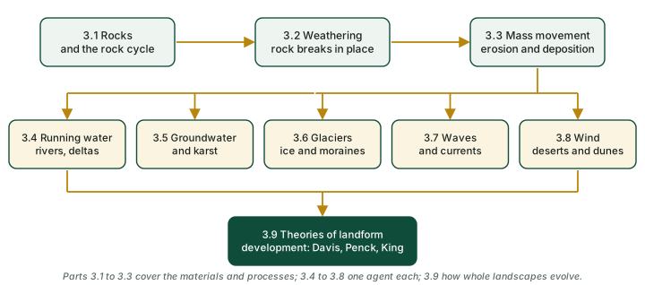
These notes cover the landforms of the earth's surface and the processes that make them, in nine parts. Rocks are the raw material; weathering loosens them, and mass movement and erosion carry the debris away; running water, groundwater, glaciers, waves and wind each carve and build their own landforms; and the theories of landform development explain how a whole landscape changes over time.
How to use this page
Boxes pick out the key ideas, the facts to remember, exam tips, pairs not to confuse, the reasons behind a pattern, worked numbers and recent news. A box whose heading calls an idea a hypothesis holds ideas scientists still debate. Every table and figure that carries data names its source beneath it, and time-sensitive figures carry their as-of date. Cross-sections and block diagrams are schematic and not to scale unless the caption says so; photographs are public-domain images from NASA, the USGS, the US National Park Service and NOAA, credited in each caption.
The diagram below shows how the parts connect.
Cross-paper relevance
- GS1 (Geography, primary): rocks and the rock cycle, geomorphic processes and weathering, mass movement, the landforms of running water, groundwater, glaciers, waves and wind, and the theories of landform development
- GS3 (Disaster management): landslides, glacial lake outburst floods, flash floods
The Nine Parts
The notes are in nine parts, in reading order. Each part has its own diagrams and sources.
- Rocks and the Rock Cycle: the eight elements that make up about 98 per cent of the crust; minerals, their ten physical characteristics and the Mohs scale; igneous rocks, intrusive and extrusive, mafic and silicic; sedimentary rocks, lithification and the three NCERT groups; metamorphic rocks, contact and regional, foliated and non-foliated, and their parent rocks; the rock cycle, and the rocks of India's Peninsula.
- Geomorphic Processes and Weathering: endogenic and exogenic forces, and gradation; geomorphic processes and agents, and the role of gravity; diastrophism (orogeny, epeirogeny, earthquakes, plate movements); exogenic processes and denudation, climate and rock structure; chemical, physical and biological weathering; exfoliation domes and tors; the significance of weathering.
- Mass Movement, Erosion and Deposition: what mass movement is, and why it is not erosion; favouring factors and NCERT's nine activating causes; slow and rapid movements on a speed scale, from creep to rockfall; landslides (slump, debris slide, rockslide, rockfall); India's landslide-prone regions, three official figures and recent events; erosion and deposition, and the five agents.
- Running Water: overland flow and stream flow, from rills to valleys; youth, maturity and old age of a river landscape; erosional landforms (valleys, gorges, canyons, waterfalls, potholes, incised meanders, terraces); depositional landforms (alluvial fans, floodplains, levees, point bars, meanders and oxbow lakes); deltas and how they are classified; India's Himalayan and Peninsular rivers, their deltas and estuaries.
- Groundwater and Karst: groundwater as a geomorphic agent and the meaning of karst; the chemistry of solution and deposition; erosional forms (swallow holes, sinkholes, uvalas, lapies and limestone pavements); caves and tunnels; depositional forms (stalactites, stalagmites and pillars); karst worldwide and India's caves.
- Glaciers: continental and valley glaciers, and how they move; erosional landforms (cirques and tarns, horns, arêtes, U-shaped valleys, hanging valleys, fjords); depositional landforms (till and outwash, moraines, eskers, outwash plains, drumlins); India's glaciers, Gangotri, Siachen and the sources of great rivers; glacial lakes and glacial lake outburst floods (GLOFs).
- Waves and Currents: how breaking waves, currents and wave refraction shape a coast; high rocky (submerged) and low sedimentary (emerged) coasts; erosional forms (cliffs, wave-cut platforms and terraces, caves, arches, stacks and stumps); depositional forms (beaches, dunes, bars, barriers, spits, lagoons and tombolos); why offshore bars, beaches and mangroves protect a coast; India's west and east coasts, kayals, Chilika and the Godavari spit.
- Wind: why deserts are the domain of wind, and why water still matters there; deflation, abrasion and impact; rolling, saltation and suspension; erosional forms (playas and alkali flats, deflation hollows, mushroom, table and pedestal rocks, ventifacts, yardangs, zeugen); desert residual hills and pediments; dunes (barchan, parabolic, seif, longitudinal and transverse) and loess; the Thar (Marusthali), its dunes, playas and inland drainage.
- Theories of Landform Development: Davis's structure, process and stage, youth, maturity and old age, peneplain and monadnock; the criticisms of Davis, including his own arid cycle (1905); Penck's uplift with erosion, convex, straight and concave slopes, parallel retreat and the Endrumpf; King's four hillslope elements, scarp retreat, pediments, pediplains and inselbergs; Davis, Penck and King compared.
Quick Revision
The whole topic at a glance
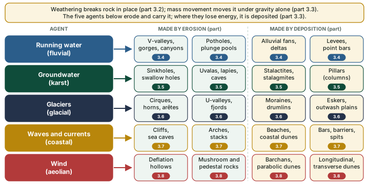
Every landform in these notes comes from two sets of processes. Weathering and mass movement prepare and move debris; then five agents (running water, groundwater, glaciers, waves and wind) erode and carry it, and drop it where they lose energy. The diagram below maps each agent to its main landforms.
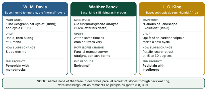
Three models try to explain how a whole landscape changes over time. The diagram below sets them side by side.
Numbers to remember
| Number | What it is |
|---|---|
| ~98% | of the crust is eight elements, led by oxygen and silicon (NCERT) |
| 2.5 / 5.5 | Mohs hardness of a fingernail / of glass or a knife blade |
| <16 mm/yr | "extremely slow" landslide class; "extremely rapid" is above 5 m/s (Hungr and others, 2014) |
| ≥50% | sand-, silt- and clay-sized particles in a mudflow; a debris flow has less (USGS) |
| 12.6% | of India's land area, excluding snow cover, prone to landslides (NRSC Atlas, 2023) |
| 8-10 / 10-20 km | width of the Bhabar / of the Tarai (NCERT) |
| 15.2% | of the ice-free land surface has karstifiable carbonate rock; 1.18 billion people live on karst (Goldscheider and others, 2020) |
| 1 km / 30 m | length / height a drumlin may reach (NCERT) |
| 676 / 130 | of 2,431 Himalayan glacial lakes, notably expanded since 1984 / of the 676, in India (ISRO, 2024) |
| 75 km | length of the Siachen Glacier (NASA, 2024) |
| <150 mm | yearly rainfall over the Thar (NCERT) |
| 15-30° | slope that King's scarps keep as they retreat (e-PG) |
Source: as given in the nine parts: NCERT, Fundamentals of Physical Geography, Class XI, 2020 edition, ch 5 (dropped from the current book); NCERT, Fundamentals of Physical Geography, Class XI (reprint 2026-27), ch 5; NCERT, Fundamentals of Physical Geography, Class XI, chapter 6 "Landforms and their Evolution" (Reprint 2026-27); NCERT, India: Physical Environment, Class XI (reprint 2026-27), ch 2; Hungr, Leroueil and Picarelli (2014), Landslides, doi:10.1007/s10346-013-0436-y; USGS FS 2004-3072; NRSC Landslide Atlas of India (2023); Goldscheider and others (2020); ISRO (April 2024); NASA Earth Observatory, Siachen (17 Mar 2024); INFLIBNET e-PG Pathshala.
Where NCERT and research differ
| Topic | NCERT (or the usual textbook account) | Research or other source |
|---|---|---|
| What a mineral is | Includes organic substances: coal, petroleum and natural gas are described as minerals that are "organic substances" (2020 edition) | NPS: "A naturally occurring inorganic crystalline solid with a definite chemical composition or compositional range" |
| Granite and syenite | Listed among examples of metamorphic rocks (2020 edition) | Both are igneous (NPS lists them among intrusive rocks); granite changed into gneiss is metamorphic |
| A block raised between faults (Satpura) | "Block mountain" | International term: horst |
| How frost breaks rock | The standard textbook answer: water expands about 9 per cent on freezing | Vlahou and Worster (2010): expansion is negligible in most cases; ice segregation in thin water films does the work. Expansion can still matter in very impermeable rock such as granite |
| Landslide | Relatively rapid, perceptible movements of relatively dry material | USGS, broadly: "a wide variety of processes that result in the downward and outward movement of slope-forming materials" |
| Point bars | One sentence places them on the "concave side" of meanders | The convex, inner bank, as NCERT's own account of meanders implies |
| Swallow hole | Small to medium, round to sub-rounded shallow depressions formed by solution | Many textbooks: the point where a surface stream disappears underground (NPS: "sinking stream") |
| Doline | Sometimes used for collapse sinks | International usage: any closed karst depression |
| Matterhorn | "The highest peak in the Alps" | Zermatt Tourism: 4,478 m and "not the highest summit" (Monte Rosa, almost directly opposite, is higher); Mont Blanc is the highest peak of the Alps |
| Source of the Alaknanda | Fundamentals of Physical Geography: Alkapuri glacier | India: Physical Environment (also NCERT): Satopanth glacier above Badrinath |
| Wave-cut terrace | A platform above the average height of the waves | International usage: the intertidal surface is a wave-cut (shore) platform; a raised one is a marine terrace (NPS) |
| Seif and longitudinal dunes | Two separate types | Research treats seif and linear (longitudinal) dunes as one family |
| Valleys in youth | "Shallow V-shaped" valleys | Davis (1899): deep valleys bounded by very steep slopes |
Source: as set out, with sources, in the nine parts. In an NCERT-based answer write the NCERT version; know the other, and name its basis if you use it.
Pairs that are easily confused
| Pair | The difference |
|---|---|
| Weathering / erosion | Rock breaks down in place / debris is acquired and carried away by an agent. |
| Mass movement / erosion | Debris moves under the direct influence of gravity, with no agent carrying it / running water, groundwater, glaciers, waves or wind pick it up and carry it. |
| Intrusive / extrusive rock | Cooled inside the crust, coarse-grained (plutonic) / cooled at the surface, fine-grained or glassy (volcanic). |
| Basic, acid / mafic, silicic | The older pair of terms / the silica bands NPS uses: mafic 45-52 per cent silica, intermediate 52-66, silicic above 66. |
| Foliated / non-foliated rock | Slate, schist, gneiss / marble, quartzite, hornfels. |
| Orogeny / epeirogeny | Mountain building with severe folding in long, narrow belts / uplift or warping of large parts of the crust. |
| Slump / debris slide | Slipping with backward rotation / without backward rotation. |
| Rock fall / rockslide | From the superficial layers of a rock face / material moving to a substantial depth. |
| Gorge / canyon | Nearly as wide at the bottom as at the top, in hard rock / wider at the top, in horizontally bedded sedimentary rock. |
| Pothole / plunge pool | Roughly circular hollow in the rocky bed of a hill stream / large, deep hole at the base of a waterfall. |
| Bhabar / Tarai | Belt 8-10 km wide where streams drop boulders and may disappear / belt 10-20 km wide where they re-emerge and make marshy ground. |
| Stalactite / stalagmite | Hangs from the roof / rises from the floor. |
| Till / outwash | Unassorted, angular debris / roughly stratified, assorted debris with rounded fragments. |
| Esker / drumlin | Sinuous ridge laid by a stream beneath the ice / smooth oval ridge mainly of till, with a blunter, steeper stoss end. |
| Off-shore bar / barrier bar | Submerged ridge parallel to the coast / a bar exposed above the water by further addition of sand. |
| Spit / tombolo | Bar keyed up to one end of a bay or attached to a headland / sediment linking an island or sea stack to the mainland (NPS; NCERT does not describe it). |
| Barchan / parabolic dune | Horns point downwind / horns point upwind, held back by vegetation. |
| Longitudinal / transverse dune | Lies along the wind / lies across it. |
| Peneplain / pediplain | Davis: the end of slope decline, with monadnocks / King: the end of scarp retreat, with inselbergs. |
Source: definitions as explained in the nine parts, with their sources there.
Exam Strategy
For Prelims: Learn the numbers above: eight elements make about 98 per cent of the crust; a fingernail rates 2.5 and glass 5.5 on the Mohs scale; a mudflow has at least 50 per cent fine particles (USGS); 12.6 per cent of India's land area is prone to landslides (NRSC, 2023); the Bhabar is 8-10 km wide and the Tarai 10-20 km; ISRO counted 676 expanding glacial lakes, 130 of them in India (2024). Learn the confused pairs in the table above, from weathering and erosion to peneplain and pediplain, and NCERT's own process lists: five chemical weathering processes (solution, carbonation, hydration, oxidation and reduction) and three ways wind erodes (deflation, abrasion and impact).
For Mains GS-I: Draw wherever the question allows: a river from source to mouth with its three stages, a slope showing weathering in place beside a slump and a stream, a glaciated valley with cirque, horn, arête, U-shaped valley and moraines, two coastal profiles, and the three models of landform development side by side. Use Indian examples: the Bhabar and Tarai, the Narmada estuary and the east-coast deltas, Gangotri and Siachen, Chilika. In an NCERT-based answer write the NCERT version; know the other, and name its basis if you use it.
Framing long answers
These practice questions were written for these notes. Each outline shows a structure, the facts worth quoting and the diagram worth drawing; write the answer in your own words within the word limit.
Describe the landforms made by running water from youth to old age, with Indian examples. (250 words)
- Open: running water is the most important agent in humid regions (NCERT). It works as overland flow (sheet erosion) and as linear flow in streams; rills grow into gullies and then valleys.
- Youth: few streams, shallow V-shaped valleys (NCERT; Davis described deep ones), broad flat divides with marshes, waterfalls where hard rock is exposed.
- Erosional forms: gorges and canyons (the Kaveri near Hogenekal; the Indus near Gilgit), potholes and plunge pools, incised meanders in hard rock, river terraces.
- Maturity: plentiful, well-integrated streams, deep V-shaped valleys, sharp divides; waterfalls disappear.
- Old age: free meanders, levees and oxbow lakes (the Burhi Gandak near Muzaffarpur), at or slightly above sea level; the end form is a peneplain with monadnocks.
- Depositional forms: alluvial fans (the Bhabar and Tarai; the Kosi megafan), floodplains, levees, point bars, braided channels with riverine islands (the Brahmaputra), deltas (the Krishna; the Ganga-Brahmaputra delta) and estuaries (the Narmada).
- Draw: a river from source to mouth with the three stages and their landforms (see Running Water).
Distinguish between weathering, mass movement and erosion. Why does NCERT keep mass movement out of erosion? (150 words)
- Weathering: breakdown of rock in place: chemical (solution, carbonation, hydration, oxidation, reduction), physical (mostly thermal expansion and pressure release; frost) and biological (see Geomorphic Processes and Weathering).
- Mass movement: debris moves "under the direct influence of gravity"; air, water and ice do not carry it. Creep, solifluction, flows, slides and falls (see Mass Movement, Erosion and Deposition).
- Erosion: the "acquisition and transportation of rock debris" by running water, groundwater, glaciers, waves and wind.
- Links: weathering aids both, but NCERT says it is not a pre-requisite for mass movement and not a pre-condition for erosion.
- Why not erosion: no agent picks the debris up; gravity alone moves it, so "mass movements do not come under erosion" (NCERT).
- Draw: one slope showing weathering in place, a slump moving under gravity and a stream carrying debris away.
Describe the erosional and depositional landforms of glaciers. Add a note on expanding glacial lakes in the Himalaya. (250 words)
- Open: glaciers move "basically because of the force of gravity", a few centimetres to a few metres a day; their erosion is "tremendous" because of the friction caused by the sheer weight of the ice (NCERT).
- How they erode: plucking and abrasion; striations show the direction of ice movement (NPS).
- Erosional forms: cirques (often with tarn lakes), horns and arêtes where cirques meet, U-shaped valleys, hanging valleys, and fjords in high latitudes.
- Deposits: till is unassorted and angular; outwash is roughly stratified and assorted.
- Depositional forms: terminal, lateral, medial and ground moraines; drumlins (up to 1 km long and 30 m or so high, stoss end blunter); eskers; outwash plains.
- India: the Ganga rises in the Gangotri glacier near Gaumukh as the Bhagirathi; Gangotri has been receding since 1780, and studies show its retreat quickened after 1971; Siachen is 75 km long (NASA).
- Glacial lakes: ISRO (2024): of 2,431 lakes larger than 10 ha, 676 have notably expanded since 1984, 130 of them in India; 601 have more than doubled; moraine-dammed lakes are the largest group (307).
- Draw: a glaciated valley with cirque, horn, arête, U-shaped valley and moraines (see Glaciers).
Why do the west and east coasts of India look so different? Explain with their landforms. (150 words)
- Model: NCERT divides coasts into high, rocky, submerged ones (rivers appear drowned; the coastline is irregular) and low, sedimentary, emerged ones (rivers extend their length by building coastal plains and deltas).
- West coast: "a high rocky retreating coast" where "erosional forms dominate"; a submerged coastal plain; rivers form no deltas; many ports (Kandla, Mazagaon, JLN, Marmagao, Mangalore, Cochin); kayals in Kerala.
- East coast: "a low sedimentary coast" where "depositional forms dominate"; an emergent coast with the deltas of the Mahanadi, Godavari, Krishna and Kaveri; fewer ports; a spit on the Godavari delta; Chilika, which the Chilika Development Authority calls Asia's largest brackish water lagoon.
- Draw: two coastal profiles: cliff, wave-cut terrace and stack; beach, bar and lagoon (see Waves and Currents).
Compare the models of Davis, Penck and King on how landscapes develop. (250 words)
- Davis (1899): landforms as a function of structure, process and stage; rapid uplift, then erosion of a stable mass; youth (deep V-shaped valleys), maturity (relief starts to fall), old age (a peneplain with monadnocks); slopes decline.
- Criticism: the long still-stand; the peneplain is theoretical (isostasy); too simple; a humid-temperate base. Davis did not ignore climate: he added an arid cycle in 1905.
- Penck (Die morphologische Analyse, 1924, published after his death): erosion goes on while the land rises; convex, straight and concave slopes reflect accelerating, constant and decelerating down-cutting; slopes retreat parallel to themselves; the end form is the Endrumpf.
- King (1953): built on African landscapes, with subtropical and semi-humid conditions as "normal"; four slope elements (waxing slope, free face, debris slope, pediment; Wood 1942); scarps retreat parallel at 15 to 30 degrees; the end form is a "multi-concave upward" pediplain with inselbergs.
- NCERT: names none of the three, but describes parallel retreat of slopes through backwasting, with inselbergs left on pediplains.
- Close: Tuan argued that the contrast between Penck and Davis is partly misleading.
- Draw: the three models side by side, as in the diagram under Quick Revision (see Theories of Landform Development).
Key Terms
Karst Topography
- Definition: NCERT defines it as follows: "Any limestone or dolomitic region showing typical landforms produced by the action of groundwater through the processes of solution and deposition is called Karst topography". Its features include swallow holes, sinkholes and dolines, uvalas and lapies (karren) at the surface, and caves with stalactites, stalagmites and pillars below. The name comes, in NCERT's words, from the "Karst region in the Balkans adjacent to Adriatic sea"; it is usually traced to the Kras plateau of Slovenia.
- Context: Rain and snowmelt take up carbon dioxide, "most often in the soil", and form carbonic acid, "a common and very weak acid" (US National Park Service), which widens cracks, joints and bedding planes and carries the rock away in solution. Beyond limestone and dolomite, the National Park Service lists marble, gypsum and halite among the rocks in which solution caves form. Karst matters for water as well as landforms: the NPS calls it "ideal for storing water as an aquifer", but water "flows quickly through it and receives little filtration". About 15.2 per cent of the ice-free land surface has karstifiable carbonate rock, and 1.18 billion people live on karst (Goldscheider and others, 2020). In India, NCERT notes that the Meghalaya plateau is rich in limestone and that heavy south-west monsoon rain has given it "a highly eroded surface".
- UPSC Relevance: Karst topography is a foundational GS1 (Geography) concept for Prelims questions on the erosional and depositional landforms of groundwater and on Indian caves, and it supports Mains answers on geomorphic processes, groundwater resources and aquifer vulnerability. Learn the landform terms (swallow holes, sinkholes and dolines, uvalas, lapies or karren, poljes, stalactites, stalagmites and pillars) and which are erosional and which depositional. Indian examples: Krem Liat Prah in the East Jaintia Hills of Meghalaya, India's longest known cave (22 km when it took the record in 2006, "a little over 31km" for the connected system by March 2018, and surveys continue), and the Borra Caves in Andhra Pradesh, "one of India's deepest", reaching about 80 m (Ministry of Tourism).
Folding and Faulting
- Definition: The US National Park Service geologic glossary defines a fold as "A curve or bend in an originally flat structure, such as a rock stratum, bedding plane, or foliation; usually a product of deformation", and a fault as "A break in rock characterized by displacement of one side relative to the other." An anticline is a fold that is generally convex upward, with the older rocks in its core; a syncline is concave upward, with the younger rocks in its core. NCERT places both processes under diastrophism: orogeny is mountain building through severe folding in long and narrow belts of the crust, and through orogeny, epeirogeny, earthquakes and plate tectonics "there can be faulting and fracturing of the crust".
- Context: Faults are named by how the blocks move (NPS glossary). In a normal fault the hanging wall appears to have moved down relative to the footwall, usually on a steep fault (45° to 90°); in a reverse fault, a contractional fault steeper than 45°, the hanging wall moves up; a thrust fault is the shallow kind (under 45°), with the hanging wall pushed up and over; in a strike-slip fault the blocks slide sideways, parallel to the fault. A horst is "An elongated, uplifted block that is bounded on both sides by normal faults that dip away from one another"; a graben is the down-dropped trough between normal faults that dip toward one another. NCERT describes the Peninsula as a rigid block that has undergone vertical movements and block faulting, and names the rift valleys of the Narmada, the Tapi and the Mahanadi and the Satpura block mountains as examples. NCERT's term is "block mountain"; the international term for such a block is "horst".
- UPSC Relevance: Folding and faulting form a foundational geomorphology concept for GS1, linked to plate tectonics, mountain building (orogeny), earthquakes, and Indian and world physiography. For Prelims, learn the definitional distinctions (anticline and syncline, horst and graben, normal and reverse fault, orogeny and epeirogeny) and the Indian examples: the Narmada and Tapi rift valleys and the Satpura block mountains (horst). For Mains GS1, the concept supports answers on landform evolution, mountain building and the link between tectonic structures and seismicity.
Sources
Each table and data figure names its source beneath it. The main documents are collected here, with a date where the source carries one. Figures not listed under image credits were drawn for these notes from the data stated in their source lines.
Main sources
Image credits
| Image | Credit and licence |
|---|---|
| Meandering Mississippi (part 3.4) | USGS/NASA/Landsat 7, 28 May 2003. Public domain. File page |
| Sandstone Cross-bedding (part 3.1) | Zion National Park, 25 May 2009. Public domain. File page |
| Devils Postpile National Monument, California (part 3.1) | NPS staff, 18 November 2003. Public domain. File page |
| Half dome granodiorite (part 3.1) | National Park Service, 30 August 2016. Public domain. File page |
| Half dome at sunset in Yosemite National Park (part 3.2) | NPS / Damon Joyce, 25 June 2006. Public domain. File page |
| Weathering of joint blocks and stages in the formation of corestones (part 3.2) | United States Geological Survey, Reston, Virginia, 30 June 1987. Public domain. File page |
| Oso Landslide aerial (part 3.3) | Mark Reid, USGS, 15 May 2014. Public domain. File page |
| Grand Canyon National Park, Recording View from Mather Point 1760 (part 3.4) | Grand Canyon National Park, 11 February 2013. Public domain. File page |
| Mississippi Delta 1976 (part 3.4) | Jesse Allen, University of Maryland's Global Land Cover Facility, and LANDSAT 1, 10 June 1976. Public domain. File page |
| Sundarbans (part 3.4) | Jesse Allen, NASA Earth Observatory (Landsat 7 data of 24 November 1999 and 17 and 26 November 2000, University of Maryland Global Land Cover Facility). Public domain. File page |
| Kaziranga National Park, Assam India, Aerial View, Satellite Image (part 3.4) | NASA image by Robert Simmon (Landsat 7 data, USGS). Public domain. File page |
| Braided River in Tibet Redraws Its Channels (part 3.4) | NASA Earth Observatory image by Michala Garrison and animations by Ross Walter, using Landsat data from the U.S. Geological Survey. Story by Madeleine Gregory, Landsat Science Office Support, 8 February 2025. Public domain. File page |
| Krishna godavari delta region (part 3.4) | NASA. Public domain. File page |
| Stalactites under Iceberg Rock - Main Corridor, Carlsbad Cavern (part 3.5) | NPS / Daniel Leifheit, Carlsbad Caverns National Park, 29 January 2018. Public domain. File page |
| Winter park florida sinkhole 1981 11 USGS (part 3.5) | Anthony S. Navoy, USGS, 9 May 1981. Public domain. File page |
| Columbia Glacier, Terminus and Terminal Moraine, Heather Island, August 24, 1968 (GLACIERS 998) (part 3.6) | Austin Post, 24 August 1968. Public domain. File page |
| Agassiz Glacier, Cirque Glacier Remnant, September 8, 1969 (GLACIERS 1629) (part 3.6) | Austin Post, 8 September 1969. Public domain. File page |
| Kukak Glacier, terminus of valley glacier and braided streams, August 26, 1969 (GLACIERS 7019) (part 3.6) | Austin Post, 26 August 1969. Public domain. File page |
| Gangotri Glacier, retreat from 1780 to 2001 (part 3.6) | NASA Earth Observatory. Public domain. File page |
| Pederson and Aialik Glaciers (part 3.6) | National Park Service, Alaska Region, 5 June 2013. Public domain. File page |
| Sea Stacks on Oregon Coast (part 3.7) | Michael Theberge, April 2009. Public domain. File page |
| CINMS kayakers explore sea caves (part 3.7) | Claire Fackler/NOAA, Channel Islands National Marine Sanctuary, 4 October 2014. Public domain. File page |
| Aerial satellite imagery of Chilika lake, Odisha (part 3.7) | NASA, 22 February 2012. Public domain. File page |
| Adam's Bridge, India-Sri Lanka (PIA24949) (part 3.7) | NASA/JPL, PIA24949, acquired 25 March 2020. Public domain. File page |
| ISS-52 Barchan Dunes and Lagoons, Southern Brazil (part 3.8) | NASA Astronaut photograph from ISS, 9 July 2017. Public domain. File page |
| Thar Desert (ASTER) (part 3.8) | NASA/METI/AIST/Japan Space Systems, and U.S./Japan ASTER Science Team, 2001. Public domain. File page |
| Dunes at sunset along the southern edge of the dune field in Great Sand Dunes National Park (part 3.8) | NPS / Debra Miller, 27 July 2008. Public domain. File page |
| All other figures | Drawn for these notes from the data given in their source lines. |