 BharatNotes
Introduction
Astronomical geography studies the Earth as a body in space: how it formed, its shape and size, how it moves, and what those motions do on the ground, from day and night to seasons, time, eclipses and tides.
How to use this page
Boxes pick out the key ideas, the facts to remember, exam tips, pairs not to confuse, the reasons behind a pattern and worked numbers. A box whose heading calls an idea a hypothesis or an estimate holds ideas scientists still debate. Every table and figure that carries data names its source beneath it, and time-sensitive figures carry their as-of date. Figures are drawn from the data (orbits, globes, curves) and are to scale only where the caption says so.
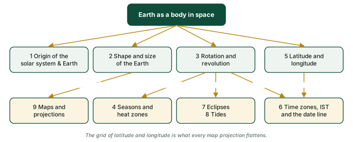
The diagram below shows how the sections connect.
Cross-paper relevance
- GS1 (Geography, primary): origin of the solar system and the Earth, shape and size, rotation and revolution, seasons and heat zones, latitude and longitude, time and the Date Line, eclipses, tides, map projections
- GS3 (Science and technology; energy): the atomic clocks of the NavIC satellites and the NVS-02 launch; India's tidal-energy potential
The Six Parts
The notes are in six parts, in reading order. Each part has its own diagrams and sources.
- Origin and Shape of the Earth: the nebular hypothesis, how the Earth formed and layered itself, the solar system in numbers and the geological time scale; then how we know the Earth is round, the oblate spheroid, the geoid, the Earth's size and how much of it is ocean.
- Rotation, Revolution and Seasons: rotation, day and night, sidereal and solar days, rotation speeds and the Coriolis effect, revolution and the leap year; then the tilted axis, solstices and equinoxes, the moving overhead Sun, insolation, length of day and the midnight Sun, heat zones and Zero Shadow Day.
- Latitude, Longitude and Time: how two angles fix any place, great and small circles, the important parallels, the length of a degree, the Prime Meridian and the 1884 conference, India on the grid; then time from longitude, local and standard time, Indian Standard Time, world time zones, the International Date Line and the clocks of NavIC.
- Eclipses: the phases of the Moon, umbra and penumbra, solar and lunar eclipses, why there is not an eclipse every month, and the eclipses of 2025 and 2026.
- Tides: what a tide is and why there are two bulges, the lunar day, spring and neap tides, daily tide patterns, why the Moon beats the Sun, what makes a tide big, and using the tides for energy.
- Maps and Projections: why every flat map distorts, cylinder, cone and plane, the Mercator projection and how much it enlarges, great circles and rhumb lines, azimuthal maps and the UN emblem, and the Equal Earth projection.
Quick Revision
The whole topic at a glance
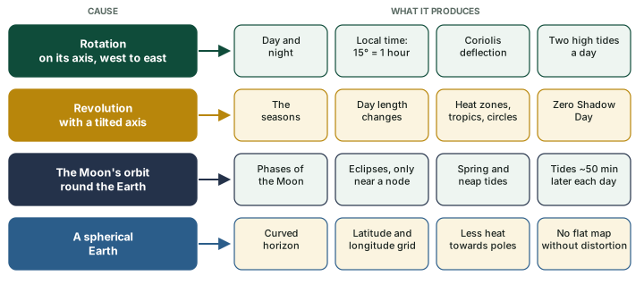
Almost everything on this page follows from four facts: the Earth spins, it orbits the Sun with a tilted axis, the Moon orbits the Earth, and the Earth is a sphere. The diagram below maps each cause to what it produces. When a question looks unfamiliar, find its cause on this chart first.
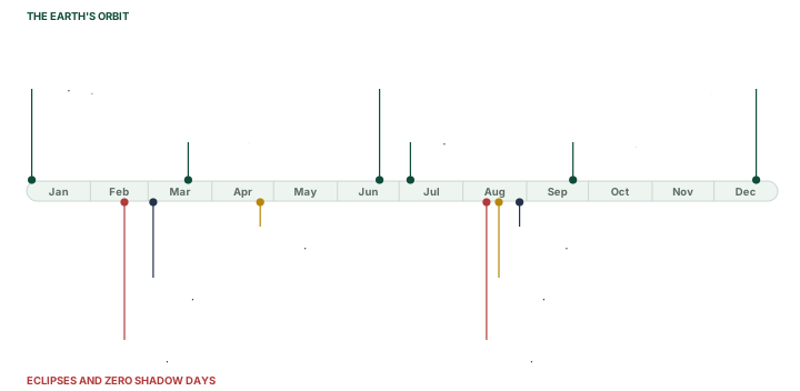
The diagram below places the year's events on one calendar. The Earth's orbital events (above the bar) repeat every year within a day or two; eclipses (below) move through the calendar from year to year, and Zero Shadow Days depend on the latitude of the place.
Numbers to remember
| Number | What it is |
|---|---|
| 23 h 56 min 4 s | one rotation relative to the stars (sidereal day) |
| 365.242 days | tropical year: season to season |
| 23.44° | tilt of the axis; 66.56° to the orbital plane |
| ~1,674 km/h | rotational speed at the equator (computed) |
| 29.78 km/s | mean orbital speed |
| 0.0167 | eccentricity of the orbit: nearly a circle |
| 6,378 / 6,357 km | equatorial / polar radius (WGS84) |
| 147.10 / 152.09 | million km: 2026 perihelion / aphelion |
| 384,400 km | mean distance of the Moon |
| 24 h 50 min | lunar day: high tides 12 h 25 min apart |
| 82° 30′ E | standard meridian of India (UTC + 5:30) |
| 4 min per 1° | of longitude; 15° per hour |
Sources: NASA Earth Fact Sheet; NASA Earth facts; WGS84 ellipsoid (EPSG:7030); Espenak; NOAA, the lunar day; NCERT Class IX, Contemporary India I, ch. 1. Equatorial speed computed: 40,075 km ÷ 23.9345 h.
Pairs that are easily confused
| Pair | The difference |
|---|---|
| Rotation / revolution | Spin on the axis, once in 23 h 56 min 4 s (relative to the stars) / orbit round the Sun, once in 365.242 days. |
| Sidereal day / solar day | One turn relative to the stars / from noon to noon, 24 h on average. They differ by about 4 minutes. |
| Perihelion / aphelion | Nearest the Sun (3 Jan 2026) / farthest (6 Jul 2026). Distance does not cause the seasons. |
| Equinox / solstice | Noon Sun overhead at the equator, day and night nearly equal everywhere / noon Sun overhead at a tropic, longest or shortest day. |
| 23.44° / 66.56° | Tilt of the axis from the perpendicular / angle between the axis and the orbital plane. |
| Latitude / longitude | Angle north or south of the equator, 0-90°, along parallels / angle east or west of Greenwich, 0-180°, along meridians. |
| Great circle / small circle | Its plane passes through the Earth's centre (the equator; any meridian with its opposite) / any other circle (every parallel except the equator). |
| Great circle / rhumb line | Shortest route between two points / line of constant compass bearing, straight on a Mercator map. |
| Local time / standard time | Set by the Sun at that meridian / one meridian's time used across a country (IST from 82° 30′ E). |
| Umbra / penumbra | Full shadow, where the light source is wholly hidden / partial shadow, where it is partly hidden. |
| Total / annular solar eclipse | The Moon covers the whole Sun / the Moon, near apogee, looks too small and leaves a bright ring. |
| Spring tide / neap tide | Sun, Earth and Moon in line (new and full moon), largest range / Sun and Moon at right angles (the quarters), smallest range. |
| Diurnal / semidiurnal tide | One high and one low tide a day / two highs and two lows of about equal size. |
Definitions as explained in the six parts, with their sources there.
Exam Strategy
For Prelims: Focus on the numbers: the tilt of the axis (23.44°), the Earth's radii (6,378 km equatorial, 6,357 km polar), the IST offset (UTC + 5:30), the standard meridian (82° 30′ E), 15° of longitude = 1 hour, why the Date Line bends, the conditions for an eclipse (only at New Moon for a solar eclipse, only at Full Moon for a lunar one), and spring versus neap tides.
For Mains GS-I: Draw diagrams wherever the question allows, above all for eclipses, tides, and the Earth's revolution and the seasons.
Framing long answers
These practice questions were written for these notes. Each outline shows a structure, the facts worth quoting and the diagram worth drawing; write the answer in your own words within the word limit.
Why does the Earth have seasons? Explain why they are reversed in the two hemispheres. (150 words)
- Open: seasons come from the tilt of the axis (23.44°) and its fixed direction in space as the Earth orbits, not from distance: the Earth is nearest the Sun on about 3 January, in the northern winter.
- Mechanism: the overhead noon Sun moves between the Tropic of Cancer and the Tropic of Capricorn. A higher Sun concentrates insolation on a smaller area, and longer days add hours of heating.
- Calendar: the equinoxes (about 20 March and 23 September) and solstices (about 21 June and 21 December), with what happens on each.
- Reversal: when the North Pole leans towards the Sun the South Pole leans away, so the hemispheres swap seasons.
- Draw: the Earth at four points of its orbit with the axis kept parallel (see the section on Seasons, Insolation and Heat Zones).
- Close: the same geometry gives the heat zones and the polar day and night.
What are tides? Explain spring and neap tides, and assess India's tidal-energy potential. (250 words)
- Define: the regular rise and fall of sea level, caused mainly by the Moon's gravity; the Sun's tide-raising force is about half the Moon's (NOAA).
- Two bulges: differences in the Moon's pull across the Earth raise water on the side facing the Moon and on the far side; rotation carries a coast through both, giving two high tides about 12 h 25 min apart.
- Spring and neap: in line at new and full moon (largest range); at right angles at the quarters (smallest range). Draw both arrangements.
- Types: diurnal, semidiurnal and mixed, with an example of where the range is extreme (Bay of Fundy).
- India: an estimated potential of about 8,000 MW, most of it in the Gulf of Khambhat, with the Gulf of Kutch and the Sundarbans (an IIT Chennai and CRISIL study, reported by MNRE to the Rajya Sabha on 2 Jan 2018). A PIB release of 22 Aug 2019 gives a later figure: about 12,455 MW of identified potential (see the section on Tides).
- Assess: predictable and carbon-free, but sites are few, capital costs are high and estuaries are ecologically sensitive. Abroad, La Rance (France, 240 MW, 1966) shows it can work.
The International Date Line does not follow the 180° meridian exactly. Explain why, with examples. (150 words)
- Open: a traveller crossing 180° meets a full day's difference: 12 hours ahead of Greenwich on one side, 12 hours behind on the other.
- Why it bends: so that a country or an island group keeps one date; the line zigzags round eastern Russia and the Aleutian Islands (NOAA).
- Examples: Kiribati put its eastern islands on the western side of the line by skipping 31 Dec 1994; Samoa skipped 30 Dec 2011 to move to the western side too.
- Status: no treaty defines it; NOAA notes it "has no legal international status". The 1884 conference chose Greenwich but did not fix a date line.
- Draw: the line's bends across the Pacific (see the section on Longitude and Time).
India follows a single standard time. Discuss the case for and against a second time zone. (250 words)
- Facts: the mainland spans about 29° of longitude (68° 7′ E to 97° 25′ E), a difference of about 2 hours in local time (117 minutes by arithmetic, which NCERT rounds to "two hours"). IST is UTC + 5:30, the local time of 82° 30′ E; CSIR-NPL maintains it.
- For a second zone (arguments made): in the North-East the Sun rises and sets far earlier than the clock suggests, so daylight working hours are lost; supporters cite energy savings and better-matched body clocks.
- Against (arguments made): confusion in railway, airline and broadcast schedules; the cost of changing systems; the value of one national time.
- Recent: the Legal Metrology (Indian Standard Time) Rules, 2026 were notified on 27 Aug 2026, published in the Gazette on 29 Aug, and come into force 180 days after publication; quote them as the current legal basis of IST.
- Close: a balanced view, noting that proposals for two zones have been made but not adopted.
Why does every flat map distort the Earth? Explain with reference to the Mercator projection. (150 words)
- Open: a sphere cannot be flattened without stretching or tearing, so every projection gives up some of area, shape, distance or direction.
- Families: cylindrical, conical and azimuthal, named after the surface the globe is projected onto.
- Mercator: it keeps local shapes and angles, so a rhumb line is straight, which made it the navigator's map; but it inflates area towards the poles, so Greenland looks as large as Africa although Africa is many times bigger (areas computed in the section on Maps and Projections).
- Draw: Tissot circles growing with latitude.
- Close: choose the projection for the purpose: equal-area for distributions, azimuthal for polar routes, Mercator for navigation.
Key Terms
Standard Time and Time Zones
- Definition: Local time is set by the Sun at each meridian; standard time is one meridian's time used across a country. A time zone is a band of 15° of longitude that keeps the time of its central meridian, a multiple of 15°, so neighbouring bands differ by exactly one hour. India keeps a single standard time, Indian Standard Time (IST), which the CSIR-National Physical Laboratory describes as "UTC(NPLI) plus 5:30 hours": the local mean time of the meridian 82°30′ E.
- Context: Relative to the Sun the Earth turns through 360° in one mean solar day of 24 hours, which is 15° of longitude an hour or 4 minutes for each degree. Local time is a fact of astronomy; standard time is a choice made by law. The International Meridian Conference of 1884 proposed Greenwich as the initial meridian for longitude but did not lay out the world's time zones. In India the Legal Metrology (Indian Standard Time) Rules, 2026 were notified on 27 August 2026 and come into force 180 days after their publication in the Official Gazette on 29 August 2026.
- UPSC Relevance: Underpins every time-difference calculation (15° = 1 hour; 1° = 4 minutes), the reason IST is UTC + 5:30, and the discussion of one time zone or two for India.
Equinox and Solstice
- Definition: At an equinox the noon Sun is overhead at the Equator and day and night are nearly equal everywhere (about 20 March and 23 September); at a solstice the noon Sun is overhead at a tropic, giving the longest or the shortest day (about 21 June and 21 December).
- Context: Both follow from the tilt of the Earth's axis, 23.44°, and its fixed direction in space as the Earth orbits the Sun: through the year the overhead noon Sun moves between the Tropic of Cancer and the Tropic of Capricorn. In 2026 the March equinox fell on 20 March at 14:46 UT and the September equinox on 23 September at 00:06 UT; the December solstice of 2026 falls on 21 December by Universal Time but on 22 December in IST. Perihelion (3 January in 2026) is a different event from the December solstice: it is about distance, not tilt.
- UPSC Relevance: The base for questions on the overhead Sun, the length of day, Zero Shadow Day, the heat zones and the reversal of the seasons between the hemispheres.
Sources
Each table and data figure names its source beneath it. The main documents are collected here, with a date where the source carries one. Figures not listed under image credits were drawn for this page from the data and formulas stated in their source lines.
Main sources
Image credits
| Image | Credit and licence |
|---|---|
| Earthrise, 24 Dec 1968 (see the section on Shape and Size of the Earth) | Bill Anders, Apollo 8, NASA. Public domain. File page |
| Total solar eclipse, 21 Aug 2017, Madras, Oregon (see the section on Eclipses) | Aubrey Gemignani, NASA. CC BY 2.0. File page |
| Total lunar eclipse, 21 Dec 2010, Arlington, Virginia (see the section on Eclipses) | Bill Ingalls, NASA. Public domain. File page |
| World land outlines on maps | Natural Earth, 1:110m physical vectors. Public domain. |
| All other figures | Drawn for this page from the data and formulas given in their source lines. |